
Monday, March 20, 2017
What You Missed – FCDOT Progress Report

Last Wednesday at FABB’s March meeting Adam Lind of FCDOT provided an update of ongoing repaving, capital projects, studies and other developments related to bicycling in Fairfax County.
2017 Repaving: 21 miles of bike lanes and sharrows will be added this year in Reston and the Dranesville and Lee Districts. Meetings on Dranesville and Lee repaving will be held on 23 March and 28 March respectively. Details are available on the FCDOT website.
Capital Projects: Bike lanes and shared used paths for Route 1, Lorton Road Extension, and Workhouse Arts Road, which includes a trail that connects to the Cross-County Trail, are almost complete.
Studies: The Little River Turnpike study is complete and will be going to the Board of Supervisors for endorsement. The Cinderbed study for a trail linking the Franconia-Springfield Metro to the Fairfax County Parkway Trail is done and the determination of project phasing is underway. Studies are underway for the Fairfax County Parkway Trail at the Dulles Toll Road, the Monroe Street Bridge over Rt. 267, and neighborhood connections to north side of Innovation Station.
Bikeshare: Twelve stations have been installed in Reston and the remaining three stations should be installed by the end of April. Eleven stations have been installed in Tysons with one more under construction and two more planned to start once locations are finalized. FCDOT is moving forward on trying to acquire TAP funding for ten new stations in Reston to expand the network south of the Dulles Toll Road.
Fairfax County Bike Map: A new map is being finalized with anticipated distribution during the first week of May. The map features routes that show levels of stress and has on-road and off-road routes.
Bicycle Wayfinding: Signs are ready for installation and should be installed by the end of April in Franconia-Springfield, Vienna Metro area, and East Falls Church-Annandale. Mile markers are being added to the Fairfax County Parkway Trail. Design of signs has started for the Fairfax County Parkway Trail and for Tysons-McLean area.
Outreach: FCDOT now has a consultant to assist with campaigns to promote safety, the bike parking program, and responsible use of bike facilities. Tentative plans are underway to conduct bike rides to tour new infrastructure.
The next FABB monthly meeting will be in Falls Church on Wednesday, 19 April, in the Dogwood Room, City Hall, 300 Park Ave. Hope you can join us.
Labels: bike map, capital projects, FCDOT, outreach, repaving, studies, wayfinding
Tuesday, February 4, 2014
Date set for Bicycle Master Plan public hearings

We're hoping the county can get more information about the plan on the web. Currently only info about Phase I, the Tysons Bike Plan, is on the Bicycle Master Plan page even though Phase II, the Countywide Plan, was completed in July 2012.
Highlights from the discussion:
Bicycle Master Plan – County is holding weekly status meetings with DPZ and consultants. BMP will go in front of Planning Commission on May 8 and Board of Supervisors June 17. Because it’s a plan amendment the process is arduous. There is not yet a draft available for FABB review. The consultant is finalizing the plan language, maps and a glossy, bound document that contains the full plan document. The Comprehensive plan will reference this bound document. The plan will be a guide, not an ordinance. Charlie’s goal is to take the glossy doc to the board (approximately April) as an information item and have a final Bicycle Advisory Committee meeting afterwards.
Wiehle/Reston East Bike Room – As of today 90 members have requested application packages. Access fobs have been delivered.You will need a sticker on your bike. The packages should go out last week in Jan first week in Feb. There is discussion of having an open house on the long weekend of Feb 15th (Presidents Day and Valentines Day), but it is not final. There will be a booklet as part of the marketing material.
Project Bike the Sites – A consultant is on board. The map might be done by BTWD. (This is info from the County Bike Pages: "The County was awarded Federal Enhancement Funds to create a family-friendly non-motorized route to Historic sites and buildings located in the Western region of Fairfax County, mostly comprised within the Sully District. The project consists of a bicycle map pinpointing historical locations over an approximate 15 mile bike loop, including wayfinding signage. The County is currently looking to hire a consultant that can provide cartographic and design services to create and print a map. FCDOT is looking to complete the projects in summer 2013."
FFX Co Parkway Signage – (Rt 50 to Rt 29) A signage plan was put together by Charlie for VDOT. The signs are going up in about two weeks. The signs are similar to McLean.
WOD & Gallows Rd – The traffic signal at that intersection is scheduled to be replaced in Fall 2014/Spring 2015. This may be the FIRST bicycle signal in Fairfax County. It will be a red/yellow/green light alongside a Ped Signal. Bicyclists will have a longer green bike signal, allowing them to enter the crosswalk even when the ped light is flashing "Don't Walk". There may be active or passive cyclists detection. There's also discussion of reducing the wait time for cyclists and pedestrians.
Bicycle Parking Guidelines are COMPLETE. Will be sent to the Board as an informational item in March.
BTWD is May 16th. 13 Pit Stops. They may move Reston from RTC to the Silver Line station. Dennis will check on the possible McLean stop
Demonstration Project in FFX Co Gov’t Center Area. There is lots of reserve road capacity near the Government Center. Gov Center Pwky has a median, so it may have buffered bike lanes. Ridgetop may also be included due to overcapacity, including re-introduction of on-street parking. Legato Rd is in the proposal. These are all together as a demo project.
Labels: bicycle master plan, fairfax county parkway trail, wayfinding, wiehle station bike room
Monday, September 2, 2013
Vienna disbands Bicycle Advisory Committee

While there is some overlap between a bicycle and pedestrian advisory committee, bicycle facilities are often very different than pedestrian facilities. In a town like Vienna with many urban sidewalks and few sidepaths, cyclists generally ride on the road, with the major exception of the W&OD Trail. As former chairman of the county Trails and Sidewalks Committee, it's been my experience that combining the two interest groups does not work well. It's difficult for pedestrians, who may not even ride a bicycle, to make decisions that affect cyclists.
The committee is to be commended for developing a number of bicycle routes in the town. They promoted bicycle safety with bike rodeos and safety events, and they did great work getting good bike parking in some of the shopping centers. We're hoping that the bicycle advisory committee is reinstated soon.

To be effective, there needs to be a dense network of route signs leading cyclists to major destinations. The sign in the photo is the only one that we saw. It's a good start and we assume many more signs are coming. Approximately 80 signs were recently placed in McLean that cyclists can use to navigate that town.
Labels: town of vienna, vienna bicycle advisory committee, wayfinding
Thursday, June 27, 2013
Supervisor Foust dedicates new McLean bike route signs
From the Connection article New Bicycle Signs Dedicated in Downtown McLean:
 |
| Photo by Alex McVeigh The Connection |
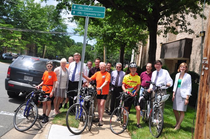
Fairfax County staff joined with bicycling advocates in downtown McLean Thursday, June 20, to celebrate the installation of several bicycle wayfinding signs. The signs give directions to bicyclists and pedestrians throughout downtown McLean to community landmarks such as the McLean Community Center, and W&OD Trail.
We’re hoping what they’ve done in McLean will set the standard for the rest of the county,” said Bruce Wright, chair of Fairfax Advocates for Better Bicycling.
More than 80 signs were installed around McLean, some of which indicate the bike route itself, while others point to specific locations, including the new Metrorail stations. Input from McLean area bicyclists was used in the creation of the routes, as well as from the county-wide Bicycle Master Plan.
“I live east of downtown, and like to bike west, toward McLean Central Park and Old Dominion Drive, and sometimes it can be hard to efficiently navigate all the side streets in downtown,” said Barry Williams, who first saw the signs Thursday afternoon. “These definitely make it easier for me, and I’d imagine they’d be very helpful for long range cyclists that are trying to get through as quickly as safely as possible, which I’m all for.”
Supervisor John Foust (D-Dranesville) said this has been a priority since he took office. Shortly after his election in 2008, he appointed a Pedestrian Task Force that gave recommendations on making McLean more accessible on bike and on foot.
“I’m excited that McLean was the first area in the county to have the benefit of these signs,” he said. “Bicycle use is increasing and these signs will be useful to both community and recreational bicyclists in the area.”
The project was funded through the county’s Commercial and Industrial Tax revenues.
Further improvements for bicyclists in McLean will be coming soon. Marcia Twomey, president of the Greater McLean Chamber of Commerce, said that 15 bicycle racks will be installed downtown in the coming months.
See also the Post article Signs map out McLean bike routes.We’re hoping what they’ve done in McLean will set the standard for the rest of the county,” said Bruce Wright, chair of Fairfax Advocates for Better Bicycling.
More than 80 signs were installed around McLean, some of which indicate the bike route itself, while others point to specific locations, including the new Metrorail stations. Input from McLean area bicyclists was used in the creation of the routes, as well as from the county-wide Bicycle Master Plan.
“I live east of downtown, and like to bike west, toward McLean Central Park and Old Dominion Drive, and sometimes it can be hard to efficiently navigate all the side streets in downtown,” said Barry Williams, who first saw the signs Thursday afternoon. “These definitely make it easier for me, and I’d imagine they’d be very helpful for long range cyclists that are trying to get through as quickly as safely as possible, which I’m all for.”
Supervisor John Foust (D-Dranesville) said this has been a priority since he took office. Shortly after his election in 2008, he appointed a Pedestrian Task Force that gave recommendations on making McLean more accessible on bike and on foot.
“I’m excited that McLean was the first area in the county to have the benefit of these signs,” he said. “Bicycle use is increasing and these signs will be useful to both community and recreational bicyclists in the area.”
The project was funded through the county’s Commercial and Industrial Tax revenues.
Further improvements for bicyclists in McLean will be coming soon. Marcia Twomey, president of the Greater McLean Chamber of Commerce, said that 15 bicycle racks will be installed downtown in the coming months.
Labels: mclean, supervisor foust, wayfinding
Wednesday, May 29, 2013
Town of Vienna bike route sign meeting notes
Last night the Vienna Transportation Safety Commission agreed to work with the Fairfax County Bike Coordinator, Charlie Strunk, a Town resident, to improve the existing bike route signage, based on public comments received at the meeting. They agreed with the chairman that it is best to make sure the initial phase is done well before moving on. Once the Town is satisfied with the existing signage they will begin signing an expanded bike route network in the second phase of the project.Bob McCahill of the Bicycle Advisory Commission submitted numerous detailed comments about the current signs. The BAC is currently not meeting pending a review of their mission by the Mayor and Town Council. Several of Bob's comments involved the need for a few additional signs to help route cyclists. He also suggested that more wayfinding and destination signs be used.
We submitted the following comments:
---
Vienna Bicycle Route Signage
- Need signs at important intersections of the W&OD Trail leading to major destinations. Signs should show direction and mileage to destinations and should be bi-directional (to and from Vienna).
- Destinations:
- Metro stations (Tysons, Dunn Loring, Vienna)
- Library
- Town Hall
- Schools
- Parks
- Playgrounds
- Tysons
- Downtown Vienna
- Need better route to Vienna Metro station. (We were later told that the "official" Metro route was along Tapawingo)
- Courthouse/Locust route is incomplete
- Courthouse is not bike-friendly
- Courthouse needs shared lane markings or Bicycle May Use Full Lane signs where the road is narrower
- I think the standard green and white bike route signs work better than the unique Vienna bike route signs.
- Incorporate Vienna bike routes into the Tysons microfiber bike route map.
- Install a kiosk at the Town Green showing information about the bike routes including a map.
- Distribute handouts/maps of the bike routes at W&OD Trail kiosks, Vienna Community Center, merchants, and so forth.
- Develop some scenic or historic signed bike routes/loops highlighting interesting sights.
We learned that Vienna Police have increased patrols on the W&OD Trail after a recent groping incident was reported by a female jogger near Talahi Rd SE.
Route signs will soon appear on Cottage St, a popular bike route leading to the Dunn Loring Metro station and the Merrifield area.
 |
| Driver wayfinding signage |
Motorists don't need signs to tell them where to go so why do we need all these bike route signs (I see three driver wayfinding signs in the image at the right of the Nutley St/Virginia Center Blvd intersection, and it was pointed out that cyclists need to know where the safe routes are located), and the classic, I pay gasoline taxes but cyclists get a free ride (we all pay taxes used to fund roads, especially local roads). His was a lone voice. Other commissioners seemed very supportive and willing to help cyclists find safe, convenient ways to navigate Vienna's streets.
Kudos to the Town for implementing their bike route network and continue to refine it. We look forward to riding in a more bike-friendly Vienna in the future.
Labels: bicycle route network, town of vienna, transportation safety commission, vienna bicycle advisory committee, wayfinding
Tuesday, May 14, 2013
New bike signage in McLean

Bike route directions are provided to the new Silver Line Tyson-McLean station, and the West Falls Church station. The signage also directs cyclists toward the W&OD trail, Arlington and more. This is one of the first installations of wayfinding signage in Fairfax County based on new bicycle sign standards.

Labels: mclean, supervisor foust, wayfinding
Saturday, January 26, 2013
Video of bike ride from DC to Tysons

I'm very familiar with most of this route which primarily consists of the Custis Trail to W&OD Trail. Part of the last section to Tysons is on a route that's new to me, the Beltway crossing on Barbour Rd.
Where the W&OD Trail crosses Shreve Lane the rider takes a right and quick left to follow Pinecastle Rd to Barbour Rd which crosses the Beltway. The rider continues on Barbour then turns left on Idylwood Rd. I am often harassed along this stretch of Idylwood Rd where drivers seem very aggressive and intolerant of bicyclists.
The rider then stops at the intersection of Idyl Lane and Idylwood Rd (see the sign for Idylwood Towers in the background) to check directions. After a short pause they head down Idyl Lane only to turn around and climb back up to Idylwood Rd, a fairly steep climb, and turns right on Idylwood. This is a really bad section that's narrow with lots of aggressive traffic. We've lobbied for better bike facilities here. There is funding for paved shoulders but there are many physical challenges to implementation. Bicycles May Use Full Lane signs were installed by VDOT last year.
The rider continues on this bad stretch of Idylwood toward Gallows Rd. There's lots of traffic and many close passes. Surprisingly the rider makes a U-turn and passes through this same section back to a left on Idyl Lane, a relatively bike-friendly road. Wayfinding signs indicating good routes to major destinations are definitely needed in Fairfax.
At Route 7 the rider turns left on the service road headed west toward Tysons. They then make their way through the parking lots and services roads parallel to Route 7, a route identified on the Tysons Master Plan as a possible bike route given a few improvements.
Where the service road ends the rider follows the sidewalk past Marshall High School. Past Marshall HS there is a service road that could have been an alternative. At Lisle Ave the rider crosses Route 7 and rides to the Westin Hotel.
While the Westin may have a Tysons address, it's on the periphery. To reach Tysons one would have to continue on Route 7 and cross the Beltway, which in the past has been one of the more dangerous places to ride. A cyclist was killed riding there in 2008 and a pedestrian was killed in the same location in 2010. Since the Route 7 bridge was rebuilt there is now a wide side path that cyclists can use.
It is possible to ride to Tysons and it's gradually getting better. With over 100,000 people working there, direct, safe bike routes with good wayfinding signs, are desperately needed.
Labels: Tysons, wayfinding
Tuesday, December 13, 2011
CTB approves new bike signage
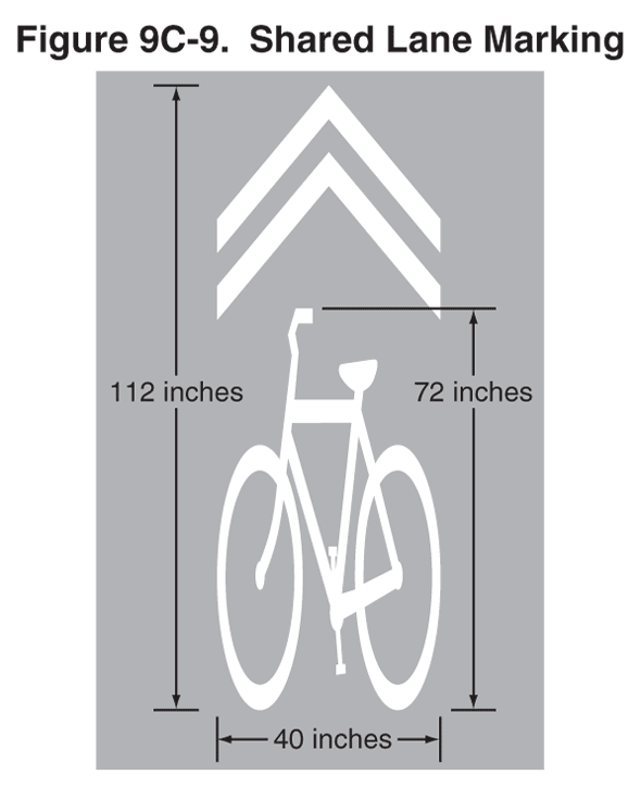
There are many roads where Shared Lane Markings should be used. Examples include where bike lanes end due to limited right of way: Gallows Road at I-66, Old Courthouse Road at Freedom Hill Park, and Westmoreland St leading to Kirby Rd. Other locations include along Idylwood Rd between the W&OD trail and Idyl Lane, and on many roads where cyclists ride and there is no room for bike lanes or wide outside lanes.
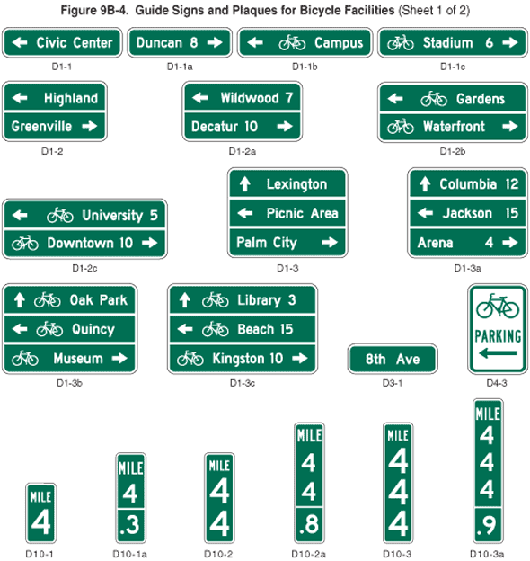

We're anxious to see the first applications of these signs.
Labels: bicycles may use full lane, mutcd, shared lane markings, wayfinding


