
Sharrows placed on Lawyers Road in Reston
 |
| Photo: Charlie Bobbish |
Sharrows, also known as Shared Lane Markings, are intended to let motorist know to expect cyclists in the road, and to guide cyclists as to where they should be riding. Here is info on use of sharrows from the national standard on traffic markings, the Manual on Uniform Traffic Control Devices:
 |
| Image from the Arlington PAL campaign |
- Assist bicyclists with lateral positioning in a shared lane with on-street parallel parking in order to reduce the chance of a bicyclist's impacting the open door of a parked vehicle,
- Assist bicyclists with lateral positioning in lanes that are too narrow for a motor vehicle and a bicycle to travel side by side within the same traffic lane,
- Alert road users of the lateral location bicyclists are likely to occupy within the traveled way,
- Encourage safe passing of bicyclists by motorists, and
- Reduce the incidence of wrong-way bicycling.
 |
| Sharrows being installed on Lawyers Rd Photo: Jeff Anderson |
Standard:
03 Shared Lane Markings shall not be used on shoulders or in designated bicycle lanes.
Guidance:
04 If used in a shared lane with on-street parallel parking, Shared Lane Markings should be placed so that the centers of the markings are at least 11 feet from the face of the curb, or from the edge of the pavement where there is no curb.
05 If used on a street without on-street parking that has an outside travel lane that is less than 14 feet wide, the centers of the Shared Lane Markings should be at least 4 feet from the face of the curb, or from the edge of the pavement where there is no curb.
06 If used, the Shared Lane Marking should be placed immediately after an intersection and spaced at intervals not greater than 250 feet thereafter.
Option:
07 Section 9B.06 describes a Bicycles May Use Full Lane sign that may be used in addition to or instead of the Shared Lane Marking to inform road users that bicyclists might occupy the travel lane.
Labels: lawyers road, shared lane markings, sharrows
New bike lane in Reston
 |
| Bike lane on USGS Drive |
Labels: bike lanes, shared lane markings, sharrows
Sharrows in Fairfax City
‘Sharrows’ Remind Motorists to Share the Road With Bikers is a recent article in Fairfax News about planned sharrows on Old Lee Highway:
This fall, the city plans to install shared-use lane markings on sections of Old Lee Highway. These markings, “sharrows,” are two chevrons pointing forward with a bicycle symbol below. Sharrows are used to indicate to cyclists where they should ride in the road. Sharrows also alert motorists to expect bicyclists to share the road.
The city also plans to install signs on Old Lee Highway reinforcing the message to share the road.
Sharrows currently mark the bike lanes on George Mason Boulevard and University Drive between the university and Old Town Fairfax.
Bicyclists have the same rights and responsibilities as motorists on the road.
Labels: city of fairfax, gmu, shared lane markings, sharrows
Town of Herndon to discuss bike plan recommendations August 14
 Herndon Town Council will hold a public hearing on August 14 starting at 7pm to discuss a resolution of support for the Countywide Bicycle Master Plan developed by the Pedestrian and Bicycle Advisory Committee. All Herndon-area cyclists are encouraged to attend the hearing and speak out in favor of the plan recommendations.
As reported here, the Town Council recently held their first public hearing on adoption of recommendations for bike lanes, sharrows, and other bike facilities that are included in the county bicycle master plan. Adoption of the recommendations will be a great step forward for helping to make Herndon a more bicycle-friendly place.
Unfortunately there was some misinformation discussed at the earlier hearing about where cyclists are allowed to ride on the road, and about the purpose of sharrows. FABB has scheduled a meeting with Town officials to discuss the use of sharrows, rights of cyclists to ride in the road, and how the sharrows will be implemented in the Town. Among other sources we'll be referencing VDOT's guidelines on use of sharrows that we wrote about extensively in an earlier post.
Labels: herndon, shared lane markings, sharrows
Herndon Town Council discusses Bicycle Master Plan

So based on the above you’d expect some discussion on how people use bicycles in the town, or perhaps how sharrows might impact safety. The discussion was in two parts: 1) discussion by the Town Council and 2) comments from the public.
The discussion from the Town Council largely centered around:
- Postponing the vote until the next meeting
- Possibility of grants to cover any costs
- How much any of these improvements will cost
- The right of a bicyclist to ride in the road
- Cycling on the sidewalks instead of the roads
- Negative reaction of drivers and homeowners if bike lanes or sharrows are used
- Discussion of how bicycles must pull over if cars approach and will be ticketed for riding in the middle of the road
- Potential delay to drivers by having bicyclists in the road
- Effectiveness and legitimacy of these on-road bicycle treatments
Comments from the Public:
- New bicycle facilities will be good for those who are older and can’t drive
- There is no possibility of bike lanes and sharrows making the road less safe
- Sharrows will decrease harassment of cyclists by drivers
- Better bicycle facilities will help more residents enjoy events like Herndon Festival since the entire town is 10 minutes or less away from downtown
- Accommodating bicycles in town will be less expensive than building parking garages
- Being more bicycle friendly may attract more of the people who ride the W&OD to the downtown area, helping businesses
- Bicycle facilities will increase the safety of Herndon Residents who cannot afford cars (of which there are many)
Do you see any common themes between what the Public thought was important compared to the Town Council? I really didn’t either. The Council voted to defer the vote until the August 14 meeting so the town engineers can review the plan.
We cannot expect the Town Council to be experts in bicycle and pedestrian safety; however, the Council received conflicting and incorrect information at the Town Council meeting. It was stated by town staff that bicycles must move over when a car comes up behind them on a narrow road and may not ride in the middle of the lane, which is allowed by Virginia State Law. FABB hopes to meet with members of the PBAC, Herndon Police Department, and the County Bicycle Coordinator to clear up any confusion on bicycle infrastructure and bicycle laws. I hope the Town Council gets the information they need to realize the benefits of a more bicycle-friendly Herndon. See the video replay of the Council meeting. Click on Video from the July 10 meeting.
Update: The Town of Herndon published this FAQ on the bike plan:
What is the Fairfax County Bicycle Transportation Plan, and how does it impact the Town of Herndon?
The Fairfax County Bicycle Transportation Plan is a comprehensive planning effort, currently under way, to make the county’s roads bicycle-friendly. The plan will consist of a map identifying locations of future bicycle facilities as well as a policy document that outlines implementation of the plan. After getting community input at a series of public meetings, Fairfax County has developed a recommendation for a bicycle facility network that includes facilities in the Town of Herndon. The county plan is expected to be considered for adoption by the Board of Supervisors in winter 2012-13.
Does the Town of Herndon have an opportunity to weigh in on the plan and make its own recommendations?
Yes. A resolution currently before the Herndon Town Council outlines specific bicycle facilities, located within the town that, if adopted by the council, will be formally endorsed for inclusion in the county plan. The Town Council will hear public comment at its public hearing on August 14, 2012, and is expected to vote on the resolution at that meeting.
Who crafted the town’s recommendations, as outlined in the resolution the council will be considering on August 14?
Upon receipt of the county draft plan, town staff worked with the town’s Pedestrian and Bicycle Advisory Committee (PBAC), a committee formed by the Town Council to study and advise on issues related to bicycle and pedestrian access and safety throughout the town. PBAC worked to refine the county plan to specifically address issues within the Town of Herndon. The PBAC recommendation was then presented to, and subsequently recommended by the town’s Planning Commission for Town Council approval.
What types of recommended bicycle facilities are included in the town’s resolution?
The PBAC recommendations call for inclusion within the county plan of bike lanes on Dranesville Road between Herndon Parkway and Park Avenue, and on Elden Street between Monroe Street and Fairfax County Parkway. The recommendations also call for cycle tracks, trails and sharrows in specific locations within the town to facilitate safe bicycle traffic. A full outline of the resolution draft is available at www.herndon-va.gov, see “What’s New.”
I see references to “sharrows” in the PBAC recommendations. What is a sharrow?
A sharrow, or shared lane marking, which is identified with a distinctive bicycle marking: 1) identifies where bicyclists should ride in a lane where on-street parking is present to reduce the chance of being impacted by the open door of a parked vehicle; 2) identifies where bicyclists should ride in lanes that are too narrow for a motor vehicle and bicycle to travel side by side in the same lane; 3) alerts road users of where bicyclists are likely to ride within the roadway; 4) encourages safe passing of bicyclists by motorists; and 5) reduces the incidence of wrong-way bicycling.
If the Town Council does not adopt the resolution making specific recommendations to the county plan, what happens then?
Fairfax County may include facilities proposed in the Town of Herndon in its comprehensive planning effort, but the plan will not be considered as part of the town’s comprehensive plan. Comprehensive plans are long-range planning documents that set policy and do not usually indicate short-term construction projects. Inclusion in the county’s plan does not place any obligation on the town to finance or construct bicycle facilities, nor does it give permission to Fairfax County to build facilities in the town.
If the Town Council does adopt the resolution, what happens then?
Should the Town Council, after hearing public comment, adopt the resolution on August 14, the town’s recommendations will be formally submitted to Fairfax County for inclusion in their plan. This action will not, however, automatically revise the town’s 2030 Comprehensive Plan. The town may opt to include its bicycle recommendations in future updates of its comprehensive plan; this would not happen without advertised public hearings before both the Planning Commission and the Town Council, so that public input may be provided.
How much will it cost to implement the county’s plan?
The costs to implement the county’s plan are unknown at this time. Should the Town Council adopt the resolution endorsing specific recommendations to the plan, the cost of implementation of bicycle facilities in the town would then be considered when bicycle facilities are added to the town’s 2030 Comprehensive Plan and Capital Improvements Plan. It is important to note that inclusion of the PBAC recommendations in the county’s plan will likely provide additional leverage should the town then apply for grants to fund the construction of bicycle facilities.
How can I get more information?
Visit the town’s Web site at www.herndon-va.gov; see “What’s New” to link to a page with information on the Fairfax County Bicycle Transportation Plan and the town’s proposed recommendations.
Labels: bicycle master plan, herndon, shared lane markings
Confusion about Bicycles May Use Full Lane Signs
 |
| Photo: Fairfax Times |
The new Bicycles May Use Full Lane signs are used "where travel lanes are too narrow for bicyclists and motor vehicles to operate side by side" according to the official guidelines for their use. The guidelines go on to state "The Bicycles May Use Full Lane sign may be used in locations where it is important to inform road users that bicyclists might occupy the travel lane."
In the article Ronald Corso, who says he's a cyclist, complains about "bikers taking up the full lane and going a fifth of the speed limit and backing up traffic." He goes on to state that he thinks the signs are illegal: "In addition, the signs appear to be in conflict with [Va. Code § 46.2-905] which states: ‘Bicyclists operating a bicycle on a roadway at less than the normal speed of traffic at the time and place under conditions then existing shall ride as close as safely practicable to the right curb or edge of roadway.’"
What Mr. Corso neglects to quote is the end of that sentence in the code, "except under any of the following circumstances:" One of those circumstances is "substandard width lanes that make it unsafe to continue along the right curb or edge."
Fortunately Randy Dittberner of VDOT knows the code and he did a good job of explaining why the signs are needed. The signs are for both cyclists and motorists. The cyclist pictured in the article (above) is demonstrating what not to do in a narrow lane, ride in the gutter. This is very dangerous. There is not enough operating room and one small mistake by a cyclist in this position could lead to a crash, potentially in the path of a following motor vehicle. The cyclist is much safer riding away from the curb. If the lane is too narrow to share with a motorist, taking the lane and forcing motorists to pass safely is the best option.
Regarding delay of traffic; bicycles on the road are part of traffic and during rush hour often travel about the speed of other traffic. Even if traffic is traveling at the posted speed, which is 35mph on Beulah Rd, bicyclists are traveling only slightly slower than other traffic. Delays for following motorists, especially on the short 1/4 mile stretch between Clarks Crossing Rd and Trap Rd where most cyclists ride on Buelah, are minimal.
We wrote about the signs not long ago, along with several articles about shared lane markings. Obviously more needs to be done by VDOT and the county to educate motorists and cyclists about the purpose of the new signs and markings and about the laws in Virginia as they apply to bicyclists.
Labels: beulah road, bicycles may use full lane, BMUFL, shared lane markings
What Are Those Bike Symbols in the Road?
 |
| Sharrow graphic from BikeArlington |
Sharrows also let motorists know to expect bicyclists in the road. Some motorists are not aware that bicyclists have the same rights and responsibilities to use the road as do motorists. Where there are no on-road bicycle facilities, bicyclists and motorists must share the road. If the road is too narrow to share, less than 14 feet, then cyclists should ride in such a way that motorists are not tempted to share the lane with them and pass dangerously close. In these cases, sharrows are placed closer to the middle of the lane.
 Another bike-related sign is appearing in Fairfax. The Bicycles May Use Full Lane sign sends the same message as the sharrow, that bicyclists belong on the road and on narrow roads they have the right to full use of the lane. These signs were recently installed on Beulah Road on a route between the W&OD Trail to/from Tysons. They also appear on a short stretch of Idylwood Road on a route between the W&OD Trail and the Pimmit Hills area.
We can all share the road. Most cyclists avoid busy commuter routes but sometimes those are the only roads for reaching their destinations. While motorists may be slowed briefly behind a cyclist, the delay is usually minor in the whole scheme of things. Until there are safe, direct bike facilities for cyclists in the county, sharing the road is the only other option.
BikeArlington has developed an excellent graphic of safety and courtesy tips for all road users. It shows various road markings and what they mean. The above sharrow graphic was extracted from that publication.
This article was cross-posted on Reston Patch.
Labels: bicycles may use full lane, shared lane markings, sharrows
VDOT criteria for placement of Sharrows and Bicycles May Use Full Lane signs
- BMUFL signs and sharrows provide similar guidance to drivers, with a few distinctions. For example, we believe that sharrows may be preferred adjacent to parked cars to better advise cyclists to stay out of the door zone.
- Both devices cost about the same to install, but they have different life expectancy. Signs will last for at least a decade, but sharrows will be constantly pummeled by traffic since they’re often directly in vehicles’ wheel paths. As such, we are concerned that sharrows may need to be refreshed frequently, which obligates us to ongoing maintenance. We are closely monitoring the sharrows on Westmoreland to see how they hold up under traffic.
- It is our initial hope that in most cases, we can achieve a significant benefit with either the sign or the marking, without installing both. This strategy will allow us to address (at least) twice as many sites for the same cost. Certainly there may be critical sites where both devices are needed and add value, and we will definitely consider doing so.
With this in mind, we elected to focus our initial deployment of sharrows on locations where there is a gap in or terminus of an existing marked bike lane. In these areas we have already made a commitment to maintaining pavement marking expressly aimed at cyclists, and the sharrow acts to extend the markings through the gap or beyond the terminus. We focused our initial deployment of BMUFL signs on locations without marked bike lanes.
Labels: bicycles may use full lane, Randy Dittberner, shared lane markings, sharrows
Bicycles May Use Full Lane signs and Sharrows
 |
| Bicycle May Use Full Lane sign on Beulah Rd |
The road now has a sign that tells motorists that Bicycles May Use Full Lane. The biggest problem encountered on this stretch is harassment by motorists. Now they know that we belong on the road and I'm hoping they show a bit more patience. This is a busy bike commuter route leading into Tysons and the signs are a welcome addition.
From Beulah Rd we continued to Trap Road, Gelding Lane, Bois Ave, Montmorency Dr to a trail that connects to Palm Springs Dr to Hidgon Dr to Pine Valley Dr. These are all quiet neighborhoods streets and it was a very pleasant ride in the cool 70 degree weather.
 |
| Getting ready for sharrows on Old Courthouse Rd |
As you can see from the photo on the left looking east toward Freedom Hill Park, VDOT has marked the spot where sharrows will soon be installed. There are plans to add paved shoulders to the road in the near future.
We've also heard there are Bicycles May Use Full Lane signs on Idylwood Rd, another road we've suggested needs the signage. We've already heard that someone has requested that sharrows also be used. The traffic and cyclist harassment is so bad on that section that we agree that both the Bicycles May Use Full Land and sharrows are needed.
Good things are happening in Fairfax. New bike lanes on Gallows Road into Tysons, and sharrows and Bicycles May Use Full Lane signs appearing in several places around the county. With the completion of the bike plan, this might be the start of a new chapter for bicyclists in Fairfax.
Labels: beulah road, bicycles may use full lane, freedom hill park, old courthouse road, shared lane markings
Fairfax Co gets first sharrows

The sharrows were installed this week. While not a panacea, they do indicate to motorists that they should expect bicyclists in the road. They indicate to cyclists where it's safest to ride, not hugging the white line or curb but into the lane. On a lane that cannot be shared safely with a motorist (less than 14 feet), cyclists should ride so that motorists aren't tempted to pass unsafely in the same lane. They should either move to the adjacent lane if possible or wait until it's safe to pass.

Labels: idylwood road, mclean, shared lane markings, sharrows, westmoreland st
VDOT guidance on use of sharrows
The guidance is meant to clarify how the devices should be used in our area. This is an important step in the implementation of these devices. We've heard that both devices will be installed on a few roads in Fairfax in the coming weeks. There will also be publicity to inform the public about why the devices are being used and what they mean.
From the guidance:
In order for these devices to be effective, they must not be overused, but rather limited to the locations where motor vehicle traffic, bicycle traffic, and roadway conditions combine to create the greatest need. As such, the following considerations apply when evaluating a roadway for the possible application of these devices:
- Neither device shall be used on roadway segments with bike lanes, since a bike lane eliminates the need for these devices.
- Neither device shall be used on roadway segments with paved shoulders 4 feet or more in width. Although cyclists are permitted to use the travel lane even where shoulders are present, these devices may inappropriately discourage some cyclists from using the shoulder.
- Both devices should be limited to roadway segments designated by the local jurisdiction’s bicycle plan as part of its bicycle network.
- Roadway segments with low traffic volume, less than 3,000 vehicles per day, should not need these devices, because they usually offer a sufficient cycling environment.
- Neither device should be used on roadway segments with traffic volume greater than 30,000 vehicles per day or speed limits greater than 35 mph. Cyclists are generally permitted to use high-volume, high-speed roadways, but these devices may encourage novice cyclists to travel on a roadway above their skill level.
- Both devices should be limited to roadway segments where travel lanes are delineated with longitudinal pavement markings or other methods. (Neither device should be used on undivided unmarked roadways.)
BIKES MAY USE FULL LANE signs shall be used only where bicyclists are permitted by the Code of Virginia1 to use the full lane. The Code of Virginia permits bicyclists to use the full lane in a “substandard width lane,” which is defined as “a lane too narrow for a bicycle . . . and another vehicle to pass safely side by side within the lane.”
Where this condition is the reason for installing the sign, its use should be limited to roadway segments where the combined width of the right-most travel lane and any paved shoulder is 10.5’ or less, excluding the gutter pan, if any.
In order to avoid overuse of the signs that would reduce their impact and effectiveness, BIKES MAY USE FULL LANE signs should be limited to roadway segments used frequently by cyclists, or where cyclists report being intimidated by nearby motor vehicle traffic.

Following are examples of locations that may benefit from Shared Lane Markings:
- Shared Lane Markings can provide guidance where there is a gap in or a terminus of an otherwise continuous bike lane, where constraints such as roadway width preclude the addition or extension of a bike lane.
- Where on-street parking is permitted and frequently occupied, Shared Lane Markings can help cyclists choose an appropriate lane position, rather than riding too close to the doors of parked cars.
- Where a roadway segment is wide enough for a bike lane in only one direction, the bike lane can be installed in the uphill direction and Shared Lane Markings can be used in the downhill direction, where cyclists are more likely to travel near the speed of motorists and may need to ride farther from the curb to have enough reaction time.
- As a substitute for a bike lane where conditions permit a bike lane to be marked
- To provide wayfinding guidance to cyclists
- To designate a roadway as a bicycle route
- On a shared-use path or other facility where motor vehicle traffic is prohibited
- In an exclusive turn lane, where they could communicate that cyclists are permitted to use the lane to travel straight through an intersection instead of using the appropriate through travel lane
When roadway segments with Shared Lane Markings are repaved, the segments should be evaluated to determine whether the pavement could be widened enough to mark a formal bike lane. Roadways with Shared Lane Markings should be a high priority for shoulder widening. If it is infeasible to widen the pavement, the segments should be evaluated to ensure that traffic and roadway geometric conditions continue to support the use of Shared Lane Markings.
OTHER CONSIDERATIONS
A BIKES MAY USE FULL LANE sign and a Shared Lane Marking should not normally be used on the same roadway segment, unless extreme conditions, such as a documented volume of heavy cyclist traffic and severe roadway geometry, are present to a degree that using both devices together would provide a significant additional benefit to the traveling public.
Labels: bicycles may use full lane, BMUFL, Randy Dittberner, shared lane markings, sharrows, SLM, vdot
Cyclist harassment

There are several roads in the greater Tysons/Merrifield area where cyclists have frequent conflicts with motorists. These are usually narrow or very busy commuter routes. Examples include the above two sections of Old Courthouse Rd and Gosnell Rd. Others include Idylwood Rd near Idyl Lane and Gallows Rd at the I-66 bridge. These roads need better accommodations for cyclists. A start would be placement of Shared Lane Markings and Bicycles May Use Full Lane signs.
Labels: aggressive driver, harassment, share the road, shared lane markings
CTB approves new bike signage
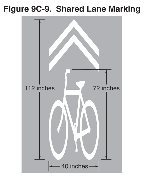
There are many roads where Shared Lane Markings should be used. Examples include where bike lanes end due to limited right of way: Gallows Road at I-66, Old Courthouse Road at Freedom Hill Park, and Westmoreland St leading to Kirby Rd. Other locations include along Idylwood Rd between the W&OD trail and Idyl Lane, and on many roads where cyclists ride and there is no room for bike lanes or wide outside lanes.
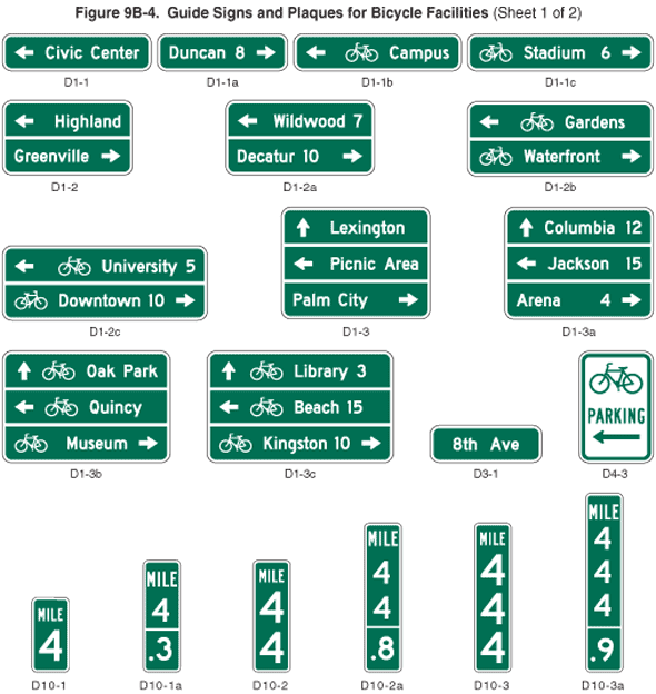

We're anxious to see the first applications of these signs.
Labels: bicycles may use full lane, mutcd, shared lane markings, wayfinding
Charlottesville to begin using sharrows

Since Virginia has not yet adopted the latest version of the MUTCD, we're wondering if the use of sharrows in Charlottesville is experimental or whether the city can proceed without VDOT having adopted the state supplement? We have a long list of roads on which sharrows are needed in Fairfax, including Idylwood Rd between Hurst and Idyl Lane, Gallows Road where the bike lanes end crossing I-66, and elsewhere.
See a video of the news report. I believe the second woman interviewed is Heather Higgins of BikeCharlottesville (incorrectly identified as the traffic engineer). Kudos to BikeCharlottesville for helping to make the city more bike-friendly:

Labels: bike charlottesville, shared lane markings, sharrows


