
Wednesday, May 6, 2015
Fairfax receives federal funds for bike/walk projects
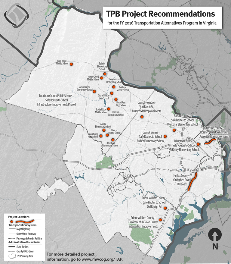
- $146,000 - Town of Vienna: Louise Archer Elementary School Missing Sidewalks
- $280,000 - Westbriar Elementary School Access - Old Courthouse Road Sidewalk
- $150,000 - Cinderbed Road Bikeway
- $280,000 – Town of Herndon: Van Buren Street Multi-modal Improvements Project
The Transportation Planning Board recently approved a number of pedestrian and bicycle improvement projects in Northern Virginia to receive funding under the federal Transportation Alternatives Program.
The $2.5 million in funding will cover the capital costs of constructing the projects, which include sidewalk enhancements, new bike lanes and bikeways, and accessibility improvements for persons with disabilities.
The projects are spread across Arlington, Fairfax, Loudoun, and Prince William counties. They were selected by the TPB based on how well they support or advance regional goals, including providing more transportation options, strengthening Activity Centers, improving access to transit, and serving disadvantaged populations.
Labels: mwcog, transportation alternatives, transportation planning board
Monday, June 9, 2014
Transportation Alternatives Projects in Fairfax County
The Metropolitan Washington Council of Governments (MWCOG) Transportation Planning Board (TPB) recently selected four projects in Fairfax County to receive funding from the Transportation Alternatives Program. Below is info from the June issue of TPB News
Board Approves Transportation Alternatives Projects for Northern Virginia
On May 21, the TPB approved 13 projects in Northern Virginia for funding under the Transportation Alternatives Program for FY 2015. The Transportation Alternatives program provides funding to projects considered "alternatives" to traditional highway construction and that expand travel choices, and enhance the transportation experience by integrating modes and improving the cultural, historical, and environmental aspects of the Washington region’s transportation infrastructure.
Fairfax County
Cinderbed Road Bikeway - Construct a 3.1 mile connection between Fort Belvoir and the Franconia-Springfield Metrorail station. Funding - $400,000
Cross County Trail in Lorton - Construct a segment of the Cross County Trail that will connect the Occoquan Regional Park and Laurel Hill Greenway via the Lorton Arts Foundation. Funding - $353,057
Safe Routes to Schools: Westbriar Elementary - Complete missing segments of sidewalk along Old Courthouse Road. Funding - $200,000
Town of Herndon
Herndon Historic Revitalization Project - Improve streetscape design and pedestrian accessibility, safety, and mobility in downtown Herndon. Funding - $6,584
Labels: mwcog, transportation alternatives, transportation planning board
Thursday, January 23, 2014
MWCOG Regional Transportation Plan - Expand Bicycle Infrastructure

Biking is mentioned throughout the Plan (pdf) as one option among many for solving our transportation problems. To reduce congestion and accommodate future growth the Plan recommends the following overall strategies, which is a major shift, from building more and bigger roads, to having an integrated, multimodal, smart growth approach:
A mix of supply-and demand-side strategies. Expanding roadway and transit capacity goes a long way in alleviating congestion on the existing transportation system, but doing so can often be more expensive and less cost-effective than efforts to manage demand.
 A multimodal approach. Offering a wider variety of travel modes, and focusing attention on modes that can move more people at lower cost, is key to moving more people more efficiently. Making such options available to more people also takes pressure off currently crowded systems, especially the roadway network and the core of the transit system, and alleviates demand for expensive new infrastructure. Providing travelers with more options also results in an increase in quality of life, as they are more likely to be able to choose a mode that best suits their individual needs. Not all projects with a given mode deserve equal attention, however; some investments or projects support more regional goals and offer greater benefit relative to their costs than others.
A focus on concentrating future growth in mixed-use Activity Centers. Land-use is a critical component in more effectively managing demand on our region’s transportation system. Concentrating growth in mixed-use Activity Centers can help make more effective use of existing facilities, and can improve socioeconomic imbalance in the region by supporting job growth and commercial activity in areas that currently lack it. These land-use principles are central tenets of Region Forward and the TPB Vision.
These recommendations "represent a shift in focus away from large-scale supply-side investments of the past to smarter, more strategic approaches to alleviating congestion and crowding, and to accommodating future growth."A multimodal approach. Offering a wider variety of travel modes, and focusing attention on modes that can move more people at lower cost, is key to moving more people more efficiently. Making such options available to more people also takes pressure off currently crowded systems, especially the roadway network and the core of the transit system, and alleviates demand for expensive new infrastructure. Providing travelers with more options also results in an increase in quality of life, as they are more likely to be able to choose a mode that best suits their individual needs. Not all projects with a given mode deserve equal attention, however; some investments or projects support more regional goals and offer greater benefit relative to their costs than others. A focus on concentrating future growth in mixed-use Activity Centers. Land-use is a critical component in more effectively managing demand on our region’s transportation system. Concentrating growth in mixed-use Activity Centers can help make more effective use of existing facilities, and can improve socioeconomic imbalance in the region by supporting job growth and commercial activity in areas that currently lack it. These land-use principles are central tenets of Region Forward and the TPB Vision.
One of the primary near-term strategies for accomplishing the above involves bicycling:
Expand Bicycle infrastructure (NT6)
What we should do: Make bicycling a viable transportation choice for more people in more places by making it safer, easier, and more convenient.- Invest in more bike lanes and bike paths
- Expand bike-sharing systems like Capital Bikeshare
- Provide more bicycle parking
- Increase workplace amenities for bicyclists, such as showers and changing rooms
Why we should do it: Responds to rising demand
Bicycling is booming in the Washington region—not just as way to get healthy and have fun, but as a practical mode of transportation. Because of this rising demand, we need to expand bicycling infrastructure to make it safer and easier for more people.
Between 2000 and 2011, the District of Columbia saw the share of its residents who bicycle to work double, from 1.4 percent of residents to 3.5 percent. Regionally, the share is still below 1 percent, but growing. Some higher- density, mixed-use communities outside the regional core have higher shares of people commuting to work by bike, like the area near the East and West Falls Church Metrorail stations, which saw 3.6 percent of commuters traveling by bike.
Interest in and support for bicycling is also growing across the region. Suburban jurisdictions are increasingly seeing that bicycling can provide a viable transportation option in locations where it was previously considered unrealistic. Fairfax and Montgomery counties, for example, are both pursuing the expansion of Capital Bikeshare into communities there. Bike to Work Day 2013 had a record 14,500 total participants, with individuals from every jurisdiction in the region pledging to commute to work by bike as part of the event.
Encourages greater use at a small price
The more bicycle infrastructure that is available, the more people are likely to ride. For example, since the year 2000, the District Department of Transportation (DDOT) has designated 56 miles of marked bike lanes, installed 2,300 bicycle parking racks, and launched Capital Bikeshare. Most of the increases in bicycle use observed over the last decade have occurred in the neighborhoods near downtown Washington, which has the highest concentration of new bike lanes, cycle tracks, and Capital Bikeshare stations. Capital Bikeshare has been particularly effective in increasing bicycling trips: in 2013, Capital Bikeshare provided an average of [X] trips per month.
Bicycling infrastructure is also relatively inexpensive to install. Bike lanes cost about $15,000 per mile and costs can be much lower if the striping is done as part of planned resurfacings or larger streetscape projects. Protected cycle tracks are more expensive to install, at approximately $200,000 per mile, but they also facilitate more bicycling than can normal lanes.
Supports activity centers and builds community
Bicycling infrastructure is a key element in community design. The TPB’s Complete Streets Policy, adopted in 2012, called upon the region’s local and state governments to adopt policies to promote street design policies and standards to make alternative modes of transportation—including bicycling and walking—safer and more comfortable. Today, nearly all the region’s jurisdictions have adopted Complete Streets approaches and are finding ways to make a range of transportation options available to more residents. Jurisdictions in all corners of the region are seeking their own ways to promote mixed-use activity centers and bicycle infrastructure to expand the number of destinations that can be reached without a car.
As we seek to improve air quality, reduce greenhouse gas emissions, and improve public health, bicycling provides the freedom to get where you need to go quickly and efficiently. Even for people who do not often bike, it represents an expansion of our options for travel. And transportation choice is a key element in our region’s vision for the future.
Labels: mwcog, regional transportation priorities plan, transportation planning board
Monday, December 24, 2012
Route 1 widening at Fort Belvoir
The Transportation Planning Board (TPB) was recently asked to amend the long range plan to include the widening of Route 1 from Fort Belvoir to Mt. Vernon Highway. The road will be widened to 6 lanes with a wide median that can accommodate future transit. Currently a 14-foot wide outside lane and a 10-foot shared use path are included in the design. The project is being funded and managed by the Federal Highway Administration. See the project website. |
| Route 1 widening project extent |
Several of the TPB members supported Allen's comments, including DC Councilman Mendelson and Hunter Mill District Supervisor Hudgins. The FHWA rep was asked to respond to their concerns at the January 23 TPB meeting. We'll be asking cyclists to send comments to the TPB in support of bike lanes in this project.
Here's Allen's statement. He modified the statement after the meeting, noting that the median is 32 feet wide and the 10-ftoo wide sidepath will not meander:
Statement to the National Capital Region Transportation Planning Board
by Allen Muchnick, VBF board member, December 19, 2012
Sadly, this proposed highway widening project illustrates a serious shortcoming of the TPB’s Complete Streets Policy and a failure of both of the Federal Highway Administration and the Virginia Department of Transportation to adhere to their own long-established bicycle accommodation policies.
This 3.4-mile segment of US Route 1 is the planned route of four, nationally significant, long-distance bicycling routes, three of which run from Maine to Florida; namely, AASHTOs US Bicycle Route 1, the East Coast Greenway, the Potomac Heritage National Scenic Trail, and the Adventure Cycling Association’s Atlantic Coast Bicycle Touring Route. As the Commonwealth of Virginia’s only north- south bicycling route (and even as the sole north-south bicycling route through the huge Fort Belvoir army base), this project should adequately accommodate experienced long-distance bicyclists who prefer to travel on the roadway which is considerably faster, much better designed and maintained, and arguably safer than the meandering shared-use path which will also be included in this project.
Since the mid 1990s, VDOT planning studies for the Route 1 corridor through Fairfax and Prince William Counties have consistently specified 15-foot wide curb lanes to accommodate bicycling, and 15-foot wide curb lanes for bicycling were specified in VDOT’s 2003 Route 1 Location Study and in the three draft Environmental Assessments which the FHWA endorsed in 2003. While 15-foot curb lanes are--at best-- a minimal bicycling accommodation on a roadway with 50 MPH design speed, the space could be striped as 4-foot bike lanes adjacent to 11-foot travel lanes to facilitate motorist overtaking and the comfort and safety of roadway bicyclists.
Unfortunately, in designing the current project, the FHWA has narrowed the long-planned wide curb lanes to 14 feet. While non-cyclists may consider this 12-inch narrowing to be a minor, those lost inches have a big impact on a bicyclist sharing a travel lane with 50 MPH traffic. It’s illogical to consider a 12- foot travel lane to be a minimal accommodation for motor vehicles, yet maintain that, by adding only two more feet, a bicyclist, who tracks at least 3 feet wide and deserves at least 3 feet of safe passing clearance, can safely share that space laterally with 50 MPH traffic. For decades, both FHWA and VDOT have issued policies and guidance for accommodating bicyclists on high-speed roadways. As early as 1990, VDOT’s bicycle accommodation policy called for routinely providing appropriate bicycling accommodations on US Bicycle Route segments, and in 1994 FHWA published guidance that a 15-foot wide curb lane is a bare minimum bicycling accommodation on a 50 MPH roadway.
Providing 15-foot curb lanes in this project does not require a wider roadway, although the proposed 27- foot landscaped median provides ample space for doing so. Instead, 15-foot curb lanes can be achieved simply by shaving 6 inches from the inside and middle travel lanes. We ask the TPB to require FHWA to provide at least 15-foot curb lanes for bicycling as a condition for adding this project to the TIP.
Labels: allen muchnick, fhwa, route 1, transportation planning board
Wednesday, December 5, 2012
Transportation training at MWCOG
 |
| Training at MWCOG |
Citizen Leaders Gather to Learn About Regional Transportation Decision-Making
A group of current or emerging citizen leaders and other interested individuals from around the Washington region gathered recently to learn about how transportation decisions are made in the region and how to become more involved in the decision-making process.
The 19 individuals, each of whom has been recognized as a force of change in his or her respective community, met on Thursday, Nov. 29, and Saturday, Dec. 1, for the Transportation Planning Board's Community Leadership Institute, or CLI, normally held in the spring and fall each year.
The first CLI took place in 2006 after TPB staff conceived it as a way to help citizen leaders connect the interests of the local communities and organizations they serve with the broader challenges facing the entire metropolitan area.
Since then, the TPB has hosted ten CLIs. At the most recent one, Todd Turner, who attended a 2008 CLI and now serves as the Chair of the TPB, welcomed participants and encouraged them to get more involved in regional decision-making.
A diverse agenda of educational presentations, experiential group learning, and interactive discussions has always been central to the CLI curriculum.
Key presentations provide participants with information about the TPB and its partners, including state and local departments of transportation and elected officials, and help explain the many different processes -- at the regional, state, and local levels -- for developing and advancing individual transportation projects.
Presentations also describe some of the key transportation challenges facing the region, especially worsening roadway congestion, inefficient land-use and development patterns, and severe funding shortfalls.
One of the main interactive group activities at the most recent session emphasized the crucial link between transportation and land-use and highlighted the challenge of accommodating future growth in the region.
In the first part of the exercise, groups each proposed on a map where to concentrate the growth of nearly 700,000 new households and more than 1.3 million new jobs that is forecast to occur through 2040 and what transportation improvements need to be made to accommodate the new growth.
Groups also had to confront the region's funding challenges in the second part of the activity by adding up the costs of their proposed improvements and identifying sources of new funding to pay for them.
One of the other main activities in the curriculum called on participants to assume the roles of different neighborhood-level interest groups in tackling a fictitious local transportation issue. The activity underscored the obstacles and opportunities that exist in trying to build consensus among people who have differing opinions and perspectives.
Peter Shapiro, who served on the Prince George's County Council from 1998 to 2004 and as Chair of the TPB in 2003, facilitated the workshop.
On Wednesday, Dec. 19, during its next regularly-scheduled meeting, the TPB will hold a brief ceremony to honor the 19 "graduates" of this fall's CLI session.
The date of the next Community Leadership Institute has yet to be set, but once it is, the TPB and its staff will begin to recruit individuals who are interested in attending and invite them to submit a formal application.
Labels: mwcog, transportation planning board
Thursday, November 29, 2012
Busy advocacy schedule
It's been a busy advocacy week for FABB. Here's a list of events and meetings we've attended this week:Tuesday, Nov. 27 - We put in a few miles riding to the following meetings, despite a light rain.
- Dunn Loring Metro Station sidewalk meeting - On Tuesday morning we met with several staff from WMATA at the station to discuss the temporary sidewalk leading into the property from the paved trail along Gallows Rd on the north. The new sidewalk is narrow and splits, with a wide lip that could, and did, catch a wheel and caused a crash. These "temporary" sidewalks will be in place for at least two years. We were told that some additional paving would be done to make the situation safer for pedestrians and cyclists.
 Tysons Bike Group meeting - Glenn Hiner of Fairfax Co Employer Services brought copies of the microfiber bike map of Tysons that he is using to promote bicycling in Tysons with the goal of reducing congestion. The map shows bicycling conditions in and around Tysons. A similar map is planned fro the area in Reston around the Wiehle Ave Metro station. Glenn also discussed the possibility of the county subsidizing small-scale, employer-based bike sharing in Tysons, similar to Patriot Bikeshare. We discussed the many funded bike projects in the Tysons area including bike lanes on Idylwood Rd between Helena and Idyl Lane, paved shoulders on Old Courthouse Rd at Freedom Hill Park, upgrading the Ashgrove Lane trail, building a new trail from Vesper Ct to the Tysons West Metro station, and sharrows and wayfinding signage in various locations.
- Tysons Stakeholder meeting - Updates on various transportation projects around Tysons. As development occurs in Tysons, developers are being requested to contribute to a Tysons-wide transportation fund to be used for trip reduction strategies, probably managed by the Tysons Partnership. Bicycling will play a role in those strategies.
- W&OD Trail Safety meeting - The Vienna Transportation Advisory Commission held a public hearing that evening on W&OD Trail safety. It was an unusual public hearing since there was no public information on which to base comments. We're well aware of many concerns expressed by some trail users regarding bad behavior, but there was no clear definition of the problems nor any proposed solutions provided beforehand. We suggested that a TSC subcommittee meet with reps from the various user groups to discuss the perceived problems and to develop suggestions. At the end of the meeting Bob McCahill, Vienna Bicycle Advisory Committee chair, presented a list of proposed safety measures. The Town Council plans to meet with reps from the Northern Virginia Regional Park Authority at a work session on Dec. 10 at 8pm to discuss the issue.

Wednesday, Nov. 28 - It was a cold but clear riding day with a very bright full moon that evening.
- Alternative Transportation event at Defense Health Headquarters - DHHQ is located just inside the Beltway on Route 50. There are no safe bike/ped crossings of the Beltway on Rt 50 and only the most experienced cyclists will try to right through the intersection. However, there are many good routes from the north, east, and south. We had a table at the mid-day event and spoke to a few of the 3,000 employees working in the building.
- Route 7 Public Citizen Information Meeting - VDOT now holds public meetings much earlier in the planning process than they did in the past. At this evening meeting information was provided regarding plans to widen Route 7 to 6 lanes between Reston Parkway and Jarrett Valley Dr. There will be multi-use trails on each side of the road. We asked about the possibility of dedicating a lane to transit service. The next citizen information meeting is scheduled for Fall of 2013 at the end of the preliminary design phase.
Thursday, Nov. 29
- Transportation Planning Board Community Leadership Training - This training is provided for free by Metropolitan Washington Council of Governments (MWCOG). This is a "workshop designed to help community activists learn how to get involved more effectively in transportation decision-making in the Washington Region." The major part of the training takes place on Saturday. The sessions have received good reviews from other who have taken them in the past. The trip to the training was multimodal: bike to bus, bus to rail, rail to DC, Capital Bikeshare to the MWCOG offices.
Friday, Nov. 30
- Historic Marker Bike Tour - We plan to meet with a cyclist interested in helping us put together a bike tour that would visit several of the historic markers located throughout the county. It would be a great way to explore the rich history of Fairfax.
Labels: dunn loring, mwcog, route 7, transportation planning board, Tysons, tysons bike group, W and OD Trail
Sunday, July 19, 2009
NVTA bashes bikes
The Northern Virginia Transportation Alliance (not to be confused with the Northern Virginia Transportation Authority) is a transportation advocacy group that supports building more road capacity throughout the DC region. Development of their top priority projects would result in increased suburban sprawl and air pollution. It's no surprise that the group is supported by major developers and their representatives. Their idea of "transportation" does not include bicycles and rarely includes transit. These are their top priority projects:- I-66 to six lanes inside the Beltway.
- Route 28 to eight lanes with limited access between Route 7 and I-66.
- Right-of-way protection and construction of key segments of the Western Bypass.
- An Eastern Bypass.
- The Loudoun County and Tri-County Parkways
Bike sharing is one of the most promising transportation ideas being used throughout Europe and is taking hold in North America. It is very popular in Paris and is helping residents replace many short motorized trips with bike trips, reducing congestion and air pollution. In the U.S. half of all trips are a 20 minute or less bike ride and nearly all are currently taken by car.
We think NVTA should stop bashing bikes and consider advocating for the most efficient and least polluting transportation mode ever invented, bicycling.
Read more about TPB's bike sharing decision on The Bike-sharing Blog and at Greater Greater Washington.
[Update July 27] Link to Transportation Planning Board Project Components for TIGER grant application that contains info on the bike sharing application, including a map of proposed coverage.
Labels: bike share, northern virginia transportation alliance, transportation planning board


