
Thursday, August 17, 2017
Route 1 Bicycle Route Upgraded
FABB member Kelley Westenhoff reports that on 1 August there was a ribbon cutting ceremony near Ft. Belvoir celebrating the completion of the Route 1 Expansion, a 3.6-mile-long road improvement project between Jeff Todd Way and Telegraph Road. As part of the expansion, the Rt. 1 Bicycle Route was upgraded significantly.


Kelley and FABB member Rick Landers joined Fairfax County Bike Coordinator Adam Lind and other local cyclists for a short but hilly bike ride to explore and enjoy some of the infrastructure before the ribbon cutting ceremony.
The new facilities include a bike lane for both directions on Rt. 1 as well as a 10-foot multiuse path that runs parallel to Rt. 1 on the west side. The multiuse path runs all the way to Lorton Road where it connects to bike facilities there.

This is an exciting development because this new infrastructure makes it possible to ride from the Ft. Belvoir area to northern Fairfax County using bike facilities the entire way. By turning east on Rt. 235 cyclists can bike to Mount Vernon and then connect with the Mount Vernon Trail. From there it is simple to connect to the Martha Custis Trail at Rosslyn and then with the W&OD near Falls Church to travel on to the Reston-Herndon-Sterling areas.
Labels: route 1, route 1 bike route, route 1 expansion
Thursday, May 11, 2017
Important Route 1 Meeting Monday May 15

From the Coalition for Smarter Growth Alert:
There are lots of improvements that we’d like to see on Route 1. Here are a few:
- Safer and more accessible transportation: Implement modern bus rapid transit along the centerline of Route 1; safer streets for walking and biking with protected bike lanes, continuous sidewalks, and narrower travel lanes; and a new street grid.
- Attractive urban design and park space: Build to the sidewalk and allow for ground floor retail, town greens and plazas, and buildings that get taller when they are closer to transit.
- Housing affordability: Preserve housing affordability for the diverse population living in nearby garden apartments and include a range of housing affordability in new development.
- Health and the environment: Include modern stormwater management to deal with excess runoff, expand stream buffers and restore streams, and expand parks and recreational opportunities for children and adults.
Labels: coalition for smarter growth, richmond highway, route 1
Thursday, January 12, 2017
Municipalities Can Be Liable For Unsafe Streets
 |
| Route 1 where pedestrian was recently killed. Image: Google Maps |
On streets with a history of traffic injuries and reckless driving like many in Fairfax County such as Routes 1 & 7, departments of transportation must implement traffic calming to make those streets safer.
From the article:
The Court of Appeals, New York’s highest court, ruled that New York City and other municipalities can be held liable for failing to redesign streets with a history of traffic injuries and reckless driving.
The ruling stems from a crash in 2004, when Louis Pascarella, driving “at least” 54 miles per hour in a 30 mph zone, struck 12-year-old Anthony Turturro as he rode a bike on Gerritsen Avenue. Pascarella later pled guilty to assault.
A civil trial jury awarded Turturro $20 million, finding the city 40 percent responsible for the crash. The city appealed, and the case made its way to the Court of Appeals, which last month rendered a 6-1 finding in favor of Turturro.
“This decision is a game-changer,” says Steve Vaccaro, an attorney who represents traffic crash victims. “The court held that departments of transportation can be held liable for harm caused by speeding drivers, where the DOT fails to install traffic-calming measures even though it is aware of dangerous speeding, unless the DOT has specifically undertaken a study and determined that traffic calming is not required.”
The ruling stems from a crash in 2004, when Louis Pascarella, driving “at least” 54 miles per hour in a 30 mph zone, struck 12-year-old Anthony Turturro as he rode a bike on Gerritsen Avenue. Pascarella later pled guilty to assault.
A civil trial jury awarded Turturro $20 million, finding the city 40 percent responsible for the crash. The city appealed, and the case made its way to the Court of Appeals, which last month rendered a 6-1 finding in favor of Turturro.
“This decision is a game-changer,” says Steve Vaccaro, an attorney who represents traffic crash victims. “The court held that departments of transportation can be held liable for harm caused by speeding drivers, where the DOT fails to install traffic-calming measures even though it is aware of dangerous speeding, unless the DOT has specifically undertaken a study and determined that traffic calming is not required.”
Labels: route 1, streetsblog nyc
Tuesday, September 15, 2015
Comment on N Kings Hwy Intersection Improvements

From the North Kings Highway (VA 241) Intersection Improvements Study page:
The Fairfax County Department of Transportation (FCDOT) is seeking to develop viable transportation improvements to address traffic issues and community concerns along North Kings Highway (VA 241) within the Penn Daw Community Business Center (CBC), including cut-through traffic, pedestrian safety and walkability.
For the last two years, FCDOT has been working with a transportation consultant to develop 4 intersection design options. Community input and feedback showed preference for 2 of the 4 proposed options (8C and 8D) which underwent a more detailed transportation analysis. Both options include:
- Removal of the existing traffic signal at North Kings Highway and School Stree.
- Conversion of School Street to a right-in/right-out access.
Labels: north kings highway, route 1
Monday, October 6, 2014
Route 1 Multimodal transportation study meeting Oct. 9
Do you want safe, convenient bike facilities along Route 1? The Route 1 Multimodal Alternatives Analysis team is holding a public meeting on Thursday, Oct. 9 at the South County Government Center to report on the current status of the work:
The Route 1 Multimodal Alternatives Analysis is a study to enhance mobility along a 15-mile segment of Route 1 between the VRE station in Woodbridge and Huntington Metro Station. Join us at the upcoming public meeting to learn about the study's findings and recommendations for improved transit, roadway, bicycle, and pedestrian facilities along Route 1.
Thursday, October 9
6:00 p.m. – 8:00 p.m. (Presentation at 6:30 p.m.)
South County Center
8350 Richmond Hwy, Alexandria
Public Transit: Fairfax Connector Route 171 and the REX
See more info about the meeting.
Thursday, October 9
6:00 p.m. – 8:00 p.m. (Presentation at 6:30 p.m.)
South County Center
8350 Richmond Hwy, Alexandria
Public Transit: Fairfax Connector Route 171 and the REX
See more info about the meeting.
Thursday, August 28, 2014
New bike access through Ft Belvoir is now open

Del. Scott Surovell recently filmed a bike ride on the road just before it was opened. It was my understanding that the outside lanes would be 14 feet wide but it's difficult to tell from the video. There is a wide shared use path on the west/south side of the road that was expected to be completed by the time the road opened on August 25.
The Fairfax County bike map now needs to be updated to include the new road and trail.
For more information on the road see the Federal Highway Administration site and the VDOT site.
The new road connects to Telegraph Road that is being widened and will include bike facilities, either bike lanes or a multi-use trail. We were contacted by a cyclist who once tried to ride a long, 75-mile loop "from Herndon, down the W & OD to the Custis, along Mt. Vernon Trail to Mt. Vernon, then attempted to 'link' over to West Ox and the Parkway Trail back up to Herndon." He was not able to find a bike-friendly connection over to West Ox Road.
The new road connects to Telegraph Road that is being widened and will include bike facilities, either bike lanes or a multi-use trail. We were contacted by a cyclist who once tried to ride a long, 75-mile loop "from Herndon, down the W & OD to the Custis, along Mt. Vernon Trail to Mt. Vernon, then attempted to 'link' over to West Ox and the Parkway Trail back up to Herndon." He was not able to find a bike-friendly connection over to West Ox Road.
When the Telegraph Road widening is completed, the long loop he mentioned should work. A cyclist could ride from Mt Vernon Trail along Mt Vernon Memorial Hwy to Jeff Todd Way at Route 1, north to Telegraph Rd, west to Beulah Rd where there are bike lanes leading north to a trail parallel to Franconia Springfield Pkwy where they could head west to the ped/bike crossing of I-95 and continue west to the Fairfax Co Parkway.
The Fairfax County bike map now needs to be updated to include the new road and trail.
Here is Del. Surovell's video of his bike ride.
Labels: delegate scott surovell, jeff todd way, mulligan road, route 1
Wednesday, March 26, 2014
Route 1 meeting tonight - speak out for better bike facilities
Cyclists should consider attending the meeting and speaking out for safe, connected bike facilities. In an earlier survey conducted by the Route 1 team, "On street bike paths separated from car traffic by parked cars or a curb," which are similar to buffered bike lanes or cycle tracks, were the preferred option. "Bike lanes on Route 1" were the second most preferred option. "Off street paths" or "More destinations in my neighborhood" were third.
We much prefer the most popular option from the survey, well-designed separated bike facilities. While parallel sidepaths can be used by bicyclists for short trips, there are many potential conflicts at driveway intersections and with pedestrians.
See the presentation from the first meeting, results of the survey, and other info on the Route 1 Analysis meeting 1 page. Click on the graph below to see a higher resolution version.

Monday, February 4, 2013
Dangerous bike conditions on Route 1 sidepath - Guest blogger Mark Murphy

The side trail is only a few years old, built as part of the Wilson Bridge Project. Soon after it opened, I found that cars making the right on red at Fort Hunt Road and cars exiting the parking lot at the Hampton Inn routinely drove across the side path, looking to their left to turn into northbound Richmond Highway traffic but never looking to their right for bicycles or pedestrians coming southbound on the trail. So as you come to these crossings, even with the right of way or the green light, you never know if a driver will pull out and hit you.
In 2011 I asked Fairfax Police to do some enforcement at the Fort Hunt Road intersection. The officer who went to the location observed a constant flow of cars running the red to turn onto Richmond Highway. I thought that some new signs and notices might make drivers more aware of the hazard, so I spent most of that year working (not very effectively) to get Fairfax County and Virginia DOT to take a look at the intersection. When I met with a staff member of Supervisor Gerry Hyland’s office and a VDOT employee at the site, I brought this photo of a sign from the City of Alexandria.
 |
| Photo by Mark Murphy |
VDOT, which controls Fairfax County’s roads, will not post any sign not on its approved list and the one I suggested isn’t on it. The VDOT technician also said he could not paint a yellow stripe on a crosswalk. Instead, VDOT and Supervisor Hyland’s office offered to make three other changes: move the "Yield to Pedestrians / $200 Fine" sign on Fort Hunt closer to the intersection, where it was more likely to be seen by drivers thinking about turning right on red; paint the crosswalk with stripes; and install another "Yield to Pedestrians / Fine" sign at the Hampton Inn entrance nearby. But after a few months, when none of those things happened, I checked back to find that Fairfax County had decided that they couldn’t do any of the things they had agreed to. Exasperated, I asked Supervisor Hyland’s office what they could do, and the staff person said she would talk with Fairfax Police about stepping up enforcement.
That was May of 2012. Every day that I commute home from work, I’m extra watchful of right-on-red drivers and cars crossing the side trail. But last month, on January 4, I was hit by a car entering the Hampton Inn parking lot. The driver didn’t see me riding along the trail, although I had on a reflective vest and two headlights. I didn’t see his turn signal, if it was on. When his car turned towards me, I slammed on my brakes but couldn’t get out of his way in time and when he hit me, I flipped up onto his car’s hood.
Thankfully, I am okay. The driver did the right thing and seemed genuinely sorry about the collision. My bumps and bruises healed and I’m looking forward to getting back on the bike when the repairs are done. The bike needs a lot of work but the driver’s insurance company is taking care of that. But Fairfax County, VDOT and Fairfax Police all failed me and, in a sense, they also failed the driver.
When VDOT and Fairfax County have been made aware of a serious safety hazard to cyclists and pedestrians, why have they done nothing about it? Instead of ignoring, then rejecting a number of ideas for improving safety at these crossings, I would like for authorities to make it their problem and come up with some solutions. VDOT and Fairfax County authorities should have to answer why nothing has been done to alert drivers that they are crossing over a bicycle and pedestrian trail.
When a bicyclist is on a bicycle-pedestrian side trail and gets hit by a car, why does the police officer say the bicyclist shouldn’t ride on the “sidewalk?” The officer came up with several excuses, like a broken streetlight and the questionable effectiveness of reflective vests, for refusing to cite the driver for the collision. The driver that crossed a bicycle path and struck a cyclist was not cited. How can that be right?
Labels: fairfax county police, fort hunt road, richmond highway, route 1, supervisor hyland, vdot
Monday, December 24, 2012
Route 1 widening at Fort Belvoir
The Transportation Planning Board (TPB) was recently asked to amend the long range plan to include the widening of Route 1 from Fort Belvoir to Mt. Vernon Highway. The road will be widened to 6 lanes with a wide median that can accommodate future transit. Currently a 14-foot wide outside lane and a 10-foot shared use path are included in the design. The project is being funded and managed by the Federal Highway Administration. See the project website. |
| Route 1 widening project extent |
Several of the TPB members supported Allen's comments, including DC Councilman Mendelson and Hunter Mill District Supervisor Hudgins. The FHWA rep was asked to respond to their concerns at the January 23 TPB meeting. We'll be asking cyclists to send comments to the TPB in support of bike lanes in this project.
Here's Allen's statement. He modified the statement after the meeting, noting that the median is 32 feet wide and the 10-ftoo wide sidepath will not meander:
Statement to the National Capital Region Transportation Planning Board
by Allen Muchnick, VBF board member, December 19, 2012
Sadly, this proposed highway widening project illustrates a serious shortcoming of the TPB’s Complete Streets Policy and a failure of both of the Federal Highway Administration and the Virginia Department of Transportation to adhere to their own long-established bicycle accommodation policies.
This 3.4-mile segment of US Route 1 is the planned route of four, nationally significant, long-distance bicycling routes, three of which run from Maine to Florida; namely, AASHTOs US Bicycle Route 1, the East Coast Greenway, the Potomac Heritage National Scenic Trail, and the Adventure Cycling Association’s Atlantic Coast Bicycle Touring Route. As the Commonwealth of Virginia’s only north- south bicycling route (and even as the sole north-south bicycling route through the huge Fort Belvoir army base), this project should adequately accommodate experienced long-distance bicyclists who prefer to travel on the roadway which is considerably faster, much better designed and maintained, and arguably safer than the meandering shared-use path which will also be included in this project.
Since the mid 1990s, VDOT planning studies for the Route 1 corridor through Fairfax and Prince William Counties have consistently specified 15-foot wide curb lanes to accommodate bicycling, and 15-foot wide curb lanes for bicycling were specified in VDOT’s 2003 Route 1 Location Study and in the three draft Environmental Assessments which the FHWA endorsed in 2003. While 15-foot curb lanes are--at best-- a minimal bicycling accommodation on a roadway with 50 MPH design speed, the space could be striped as 4-foot bike lanes adjacent to 11-foot travel lanes to facilitate motorist overtaking and the comfort and safety of roadway bicyclists.
Unfortunately, in designing the current project, the FHWA has narrowed the long-planned wide curb lanes to 14 feet. While non-cyclists may consider this 12-inch narrowing to be a minor, those lost inches have a big impact on a bicyclist sharing a travel lane with 50 MPH traffic. It’s illogical to consider a 12- foot travel lane to be a minimal accommodation for motor vehicles, yet maintain that, by adding only two more feet, a bicyclist, who tracks at least 3 feet wide and deserves at least 3 feet of safe passing clearance, can safely share that space laterally with 50 MPH traffic. For decades, both FHWA and VDOT have issued policies and guidance for accommodating bicyclists on high-speed roadways. As early as 1990, VDOT’s bicycle accommodation policy called for routinely providing appropriate bicycling accommodations on US Bicycle Route segments, and in 1994 FHWA published guidance that a 15-foot wide curb lane is a bare minimum bicycling accommodation on a 50 MPH roadway.
Providing 15-foot curb lanes in this project does not require a wider roadway, although the proposed 27- foot landscaped median provides ample space for doing so. Instead, 15-foot curb lanes can be achieved simply by shaving 6 inches from the inside and middle travel lanes. We ask the TPB to require FHWA to provide at least 15-foot curb lanes for bicycling as a condition for adding this project to the TIP.
Labels: allen muchnick, fhwa, route 1, transportation planning board
Tuesday, June 5, 2012
Important meetings today
Bicycle Master Plan Meeting - North county - Learn about the proposed bicycle master plan recommendations at a public meeting at the Reston Regional Library starting at 6:30 p.m. This is one of two public meetings that will give cyclists an opportunity to learn about the plan and provide valuable feedback before the plan is finalized. The South county meeting is tomorrow in Annandale.For more information on the project see the Bicycle Master Plan website.
Route 1 Public Hearing - On the proposed widening of Route 1. The meeting starts at 6pm at Hayfield Secondary School, 7630 Telegraph Road, Alexandria, VA 22315. According to Allen Muchnick of Virginia Bicycling Federation: "This segment of US Route 1 is a desired alignment for four long-distance bicycle routes: US Bike Route 1, the Adventure Cycling Association's Atlantic Coast Route, the East Coast Greenway, and the Potomac Heritage National Scenic Trail."
"Therefore, first-rate accommodations for ALL types of bicyclists--including experienced, long-distance roadway cyclists--are critically needed in this project. While a 10-foot sidepath and 14-foot curb lanes are both currently proposed for this project, the proposed on-road bicycling space adjacent to 50+ MPH traffic is inadequate."
"Please submit a written comment asking for 15-foot curb lanes, each ideally striped as an 11-foot travel lane beside a 4-foot wide bike lane (to the left of a 2-foot wide concrete gutter)." Written comments should be sent to Jack.VanDop@dot.gov by June 29, 2012.
Labels: bicycle master plan, route 1
Thursday, May 24, 2012
Public meeting on bike facilities on Route 1
 |
| Route 1 profile showing wide curb lanes and paved trail |
Often bicycle facilities are one of the first options to be cut from a widening project to reduce the overall width. See the proposed road profile (large pdf). All project documents on the FHWA website, including a summary of comments from the 2010 public scoping meeting that includes several references to the need for better bicycling facilities in the corridor.
A public meeting on the project is planned for Tuesday, June 5, at Hayfield Secondary School, 7630 Telegraph Road, Alexandria, VA 22315, from 6-8pm. Cyclists need to attend the meeting and speak out for safe, convenient bike facilities as part of the Route 1 project. See a Patch article about the public meeting.
See the MtVernon Patch article Mount Vernon-Area Bicyclists Could Have an Easier Commute
"Route 1 as it is now is just not adequate for bicyclists," Belle View resident Mark Murphy said. "The curb lanes are narrow and traffic is heavy and fast. There are frontage roads along some parts of Richmond Highway, but they don't run consistently."
"In my opinion, Route 1 should have striped bike lanes, but someone in VDOT did not want to promote bicycling on that high-speed roadway, and the 15 feet of space could readily be reallocated at a future time into an 11-foot travel lane plus a 4-foot bike lane," Allen Muchnick, Virginia Bicycling Federation board member.
There is a 10 foot paved trail proposed for one side of the road but it does nothing for cyclists taking short trips along the opposite side of the road. Cyclists taking longer trips generally prefer an on-road route."In my opinion, Route 1 should have striped bike lanes, but someone in VDOT did not want to promote bicycling on that high-speed roadway, and the 15 feet of space could readily be reallocated at a future time into an 11-foot travel lane plus a 4-foot bike lane," Allen Muchnick, Virginia Bicycling Federation board member.
According to Allen Muchnick of VBF, "Route 1 is of particular importance for bicycling nationally as a desired alignment for four long-distance bicycling routes: US Bicycle Route 1, the Adventure Cycling Association's Atlantic Coast Route, the Potomac Heritage National Scenic Trail, and the East Coast Greenway. Thus, providing first-class bicycling accommodations for all types of bicyclists is particularly important for this project."
See other coverage of Route 1 topics on the FABB blog.
Labels: allen muchnick, fhwa, mark murphy, route 1, vdot, woodlawn national historic site
Tuesday, December 20, 2011
Patch article about Route 1 corridor
Transportation and Transit Studies Under Way for Route 1 Corridor is the title of a Huntington-Belle Haven Patch article by Rachel Leonard. It's the first of a three-part series on the future of the Route 1 corridor. The article gives a good overview of the challenges faced by cyclists:Cyclists Weigh In
Adam Froelig, transportation liaison for the Huntington Community Association, likens cycling on Route 1 to “taking our lives in our own hands.”
“I would not cycle to Target,” Froelig said. “I would be more apt to cycle to the Target at Potomac Yards, which is four miles away, than the one at Beacon Hill, which is one-and-a-half miles away, just because bicycle accommodation is better going throughout Alexandria.”
Froelig’s transportation wish list includes bike lanes, turn lanes, speeds between 35 and 45 mph, timed signals, wide sidewalks and Metro.
Fairfax Advocates for Better Bicycling member Mark Murphy of Huntington said new developments have made Route 1 more accessible from Alexandria, but heading south on Route 1 past Huntington is difficult.
“The lights and the traffic are very unfriendly,” he said. “It can be dangerous to cross some of the intersections at Route 1 because drivers just aren’t looking for bikers.”
Cyclists are also interested in improved access from Route 1 to the Huntington Metro station. Murphy sees an opportunity to build better cycling amenities as Route 1 is redeveloped.
“It’s a now-or-never situation, I think, where they can keep cyclists and pedestrians in mind when they’re designing or redesigning Route 1,” he said. “They have a chance to make some improvements that would last a long time. It would be a lot harder to go in later and put something in after the fact.”
The county is currently formulating the Fairfax Countywide Bicycle Transportation Plan and has held multiple information sessions to gather input from cyclists. Bob Patten, a senior planner with Toole Design Group, the consultancy working with the county, said he hopes to have a draft plan ready to submit to the county’s Bicycle Advisory Committee in April.
Feedback from a Nov. 17 information session in Mount Vernon included comments that cycling the corridor is especially difficult during rush hours, that a lack of an alternative to Route 1 between Huntley Meadows Park and the neighborhoods south and west of Little Hunting Creek is a major barrier, that a trail along Cameron Run between Telegraph Road and Route 1 should be built, and that safety improvements are needed for cyclists coming and going from Wilson Bridge.
Labels: bicycle master plan, route 1
Friday, November 18, 2011
Cyclists turn out for Mt. Vernon area bike plan meeting
 |
| Bob Patten (left) taking notes on local bike conditions. |
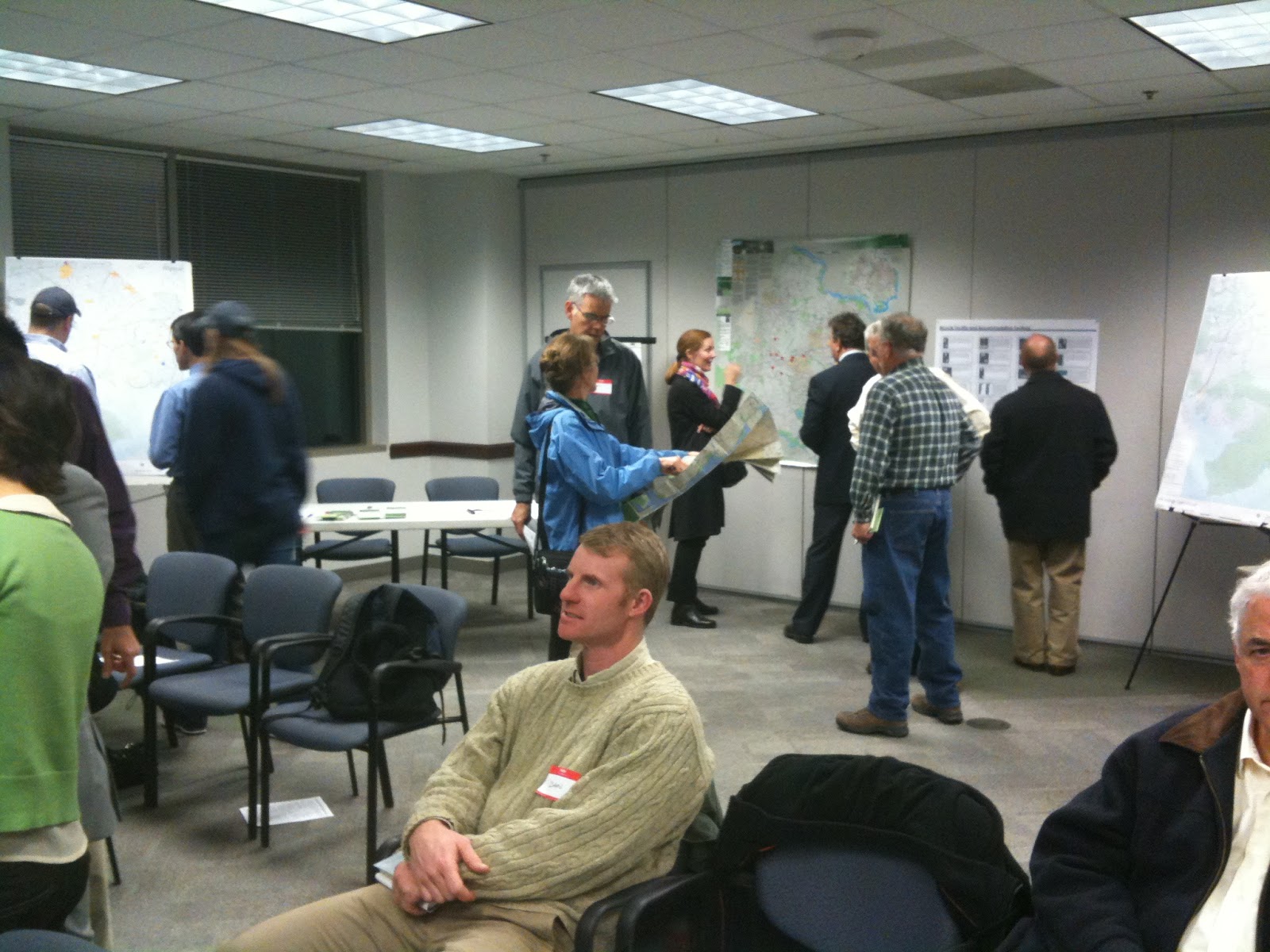
Bicycle Master Plan meeting for the greater Mt. Vernon area last night. Representatives from VDOT, Fairfax Co., and the Board of Supervisors attended as did members of FABB.
After cyclists studied and commented on detailed maps of the area, Bob Patten of Toole Design gave an overview of the master planning process. He also described several types of bicycle facilities such as cycletracks, buffered bike lanes, shared lane markings (sharrows), and others.
Bob stated that the plan will result in a map showing specific facilities proposed for roads in the county. There will also be policy recommendations to ensure that county policies treat bicycling as an integral part of the transportation system. These not only include bike route facilities but also bike parking requirements, opportunities for bicycle safety education at all levels, improved enforcement, and encouragement of bicycling by using such measures as transportation demand management incentives.
Several natural and manmade barriers make cycling in this area a challenge. Route 1 is the biggest challenge. Few cyclists choose to ride with 45 mph traffic and there are almost no side paths along the road. Many of the surrounding neighborhood streets don't connect, especially on the south side.
Just north of Route 1, Huntley Meadows Park and Fort Belvoir form another barrier. For a 2 mile stretch just north of Mt. Vernon Estate, Little Hunting Creek is a major barrier between several residential neighborhoods, forcing cyclists to use either the Mt. Vernon Trail or Route 1.
There are several major attractions in the area including Mt. Vernon Estate, Mason Neck State Park and Natural Wildlife Refuge, Pohick Bay Regional Park, Huntley Meadows Park, and Fort Hunt National Park. U.S. Bike Route 1, the East Coast Greenway, and the Adventure Cycling Atlantic Coast route all pass through this area. The area could be a major cycling destination if there were good bicycle routes connecting major attractions. It's going to take the work of everyone to make this happen.
Labels: bicycle master plan, east coast greenway, mt. vernon, route 1, U.S. bike route system
Wednesday, November 2, 2011
Route 1 widening includes bike facilities

Virginia has secured a $180 million grant from the Defense Department's Office of Economic Adjustment to widen Route 1 in the area of Fort Belvoir to six lanes between Telegraph Road and Mount Vernon Highway. The 3.5-mile widening could begin as early as 2013 and take up to three years to complete.
"Widening Route 1 is critical to ensuring a viable transportation network in the Fort Belvoir area," said Governor McDonnell. "Our nation's wounded warriors, veterans and their families deserve to have reliable and safe access to Fort Belvoir's new Community Hospital. Moreover, every day, commuters are stuck in long traffic queues on Route 1 that has only worsened with the additional traffic generated by BRAC changes bringing more defense personnel to Fort Belvoir. This widening will improve the quality of life for thousands of commuters and visitors."
The Virginia Department of Transportation (VDOT) and Fairfax County submitted joint grant applications earlier this year requesting funding to accommodate the increased traffic generated by the Base Realignment and Closure (BRAC) and the new Fort Belvoir Community Hospital which will generate 574,000 trips annually. VDOT estimates the widening will cost $180 million, including $53 million to acquire right of way, $20 million to relocate utilities, $10 million for environmental mitigation and $97 million for construction.
The portion of Route 1 serving Fort Belvoir is only two lanes in each direction, carries 56,000 vehicles a day and has one of the highest highway crash rates in northern Virginia. Between 2006 and 2008 there were 294 crashes on the 3.4-mile section between Telegraph Road and Mount Vernon Memorial Highway, including 13 injuries and one fatality. In 2011 two more fatalities occurred. In addition, Route 1 in this area lacks pedestrian and bicycle access and crosswalks at intersections.
Allen Muchnick of Virginia Bicycling Federation sent the following letter to FHA requesting that the 14-foot outside lanes planned for the Route 1 widening be modified to allow striping of 4-foot bike lanes instead:"Widening Route 1 is critical to ensuring a viable transportation network in the Fort Belvoir area," said Governor McDonnell. "Our nation's wounded warriors, veterans and their families deserve to have reliable and safe access to Fort Belvoir's new Community Hospital. Moreover, every day, commuters are stuck in long traffic queues on Route 1 that has only worsened with the additional traffic generated by BRAC changes bringing more defense personnel to Fort Belvoir. This widening will improve the quality of life for thousands of commuters and visitors."
The Virginia Department of Transportation (VDOT) and Fairfax County submitted joint grant applications earlier this year requesting funding to accommodate the increased traffic generated by the Base Realignment and Closure (BRAC) and the new Fort Belvoir Community Hospital which will generate 574,000 trips annually. VDOT estimates the widening will cost $180 million, including $53 million to acquire right of way, $20 million to relocate utilities, $10 million for environmental mitigation and $97 million for construction.
The portion of Route 1 serving Fort Belvoir is only two lanes in each direction, carries 56,000 vehicles a day and has one of the highest highway crash rates in northern Virginia. Between 2006 and 2008 there were 294 crashes on the 3.4-mile section between Telegraph Road and Mount Vernon Memorial Highway, including 13 injuries and one fatality. In 2011 two more fatalities occurred. In addition, Route 1 in this area lacks pedestrian and bicycle access and crosswalks at intersections.
Mr. Jack Van Dop
Environmental Specialist
Federal Highway Administration
Eastern Federal Lands Highway Division
21400 Ridgetop Circle
Sterling, VA 20166
Dear Mr. Van Dop:
I'm writing to comment on the proposed design for the above-referenced highway widening project, as described in your agency's brochure for the October 19, 2011 public meeting. Although the official public comment period ended yesterday (10/31/11), I only became aware of this project this afternoon after seeing Governor McDonnell's news release about the $180 million Department of Defense funding award. Thus, I hope you will include this comment as part of the official record of your October 19, 2011 public meeting.
This 3.4-mile segment of US Route 1--between Mount Vernon Memorial Highway and Telegraph Road--is a vital link for local, regional, and long-distance bicycle travel and could serve as a key link in the East Coast Greenway, the Potomac Heritage National Scenic Trail, and/or U.S. Bicycle Route One. Because of its importance for long-distance bicycling, it's critical that this project include exemplary accommodations for all types of bicyclists, including skilled, faster, and longer-distance bicyclists.
The "Current Proposed 148-foot Typical Section" illustrated in the meeting brochure seems amply wide to accommodate all needed pedestrian and bicycle facilities as well as a dedicated transitway in the median, in addition to six roadway travel lanes. However, in view of the high (50+ MPH) motor vehicle speeds on this roadway, the 14-foot wide "Oversized Outside Lane[s] to Accommodate Bicycles" should be designed and striped as dedicated bike lanes and continued on the *left* side of *all* right-turning lanes at the approaches to *all* intersections. To best execute these bike lanes, the middle and inside travel lanes could be striped 6 to 12 inches narrower than illustrated in the meeting brochure, to provide an 11-foot wide outside travel lane plus a 4-foot wide bike lane (to the left of the concrete gutter pans) in lieu of the 14-foot wide "oversized outside lane" illustrated in the meeting brochure.
Thank you for considering this comment. Please do not hesitate to contact me if you need more information, and please include my email address and/or other contact information in future project announcements.
Sincerely,
Allen Muchnick, board member
Virginia Bicycling Federation
While the widening project will provide bike facilities, it will make the road more dangerous for pedestrians and some bicyclists. The wide road and speeding traffic, in a busy commercial area, are a deadly mix. The speed limit should be lowered and much better bicycle and pedestrian accommodations are needed in this corridor.Environmental Specialist
Federal Highway Administration
Eastern Federal Lands Highway Division
21400 Ridgetop Circle
Sterling, VA 20166
Dear Mr. Van Dop:
I'm writing to comment on the proposed design for the above-referenced highway widening project, as described in your agency's brochure for the October 19, 2011 public meeting. Although the official public comment period ended yesterday (10/31/11), I only became aware of this project this afternoon after seeing Governor McDonnell's news release about the $180 million Department of Defense funding award. Thus, I hope you will include this comment as part of the official record of your October 19, 2011 public meeting.
This 3.4-mile segment of US Route 1--between Mount Vernon Memorial Highway and Telegraph Road--is a vital link for local, regional, and long-distance bicycle travel and could serve as a key link in the East Coast Greenway, the Potomac Heritage National Scenic Trail, and/or U.S. Bicycle Route One. Because of its importance for long-distance bicycling, it's critical that this project include exemplary accommodations for all types of bicyclists, including skilled, faster, and longer-distance bicyclists.
The "Current Proposed 148-foot Typical Section" illustrated in the meeting brochure seems amply wide to accommodate all needed pedestrian and bicycle facilities as well as a dedicated transitway in the median, in addition to six roadway travel lanes. However, in view of the high (50+ MPH) motor vehicle speeds on this roadway, the 14-foot wide "Oversized Outside Lane[s] to Accommodate Bicycles" should be designed and striped as dedicated bike lanes and continued on the *left* side of *all* right-turning lanes at the approaches to *all* intersections. To best execute these bike lanes, the middle and inside travel lanes could be striped 6 to 12 inches narrower than illustrated in the meeting brochure, to provide an 11-foot wide outside travel lane plus a 4-foot wide bike lane (to the left of the concrete gutter pans) in lieu of the 14-foot wide "oversized outside lane" illustrated in the meeting brochure.
Thank you for considering this comment. Please do not hesitate to contact me if you need more information, and please include my email address and/or other contact information in future project announcements.
Sincerely,
Allen Muchnick, board member
Virginia Bicycling Federation
Labels: fort belvoir, route 1, vdot


