
Wednesday, March 26, 2014
New Fairfax County Parkway trail signage installed
VDOT recently installed wayfinding signage on the Fairfax County Parkway trail between Route 50 and Route 29. FABB has been advocating for these signs since we formed in 2005. Thanks to VDOT and Fairfax County for working together to install the signs. |
| New Fairfax Co Parkway trail signs |
The trail diverges from the Parkway in this area and continues along West Ox Road to reconnect with the Parkway just south of Route 29. Until now trail users were left to fend for themselves. Several cyclists have said they have gotten lost when the Parkway trail suddenly diverted from the Parkway at Monument Drive and West Ox Rd. These signs will be a big help to all trail users.
The county recently allocated $80,000 to place signs on the full length of the Fairfax County Parkway and Franconia-Springfield Parkway (item 117 on Approved Projects List).
In other news about the Parkway trail, work will begin this month, starting at the Route 7 end, on repairing and repaving sections of the trail. FABB worked closely with VDOT to identify needed repairs and to develop a strategy for informing cyclists about the progress of the work.
From the VDOT news release about the new signs:
Fairfax County Parkway Bike Trail Signs – VDOT placed a series of new signs to help Fairfax County Parkway trail bicyclists navigate through Fair Lakes. The FC Parkway bike trail separates from the main roadway in Fair Lakes in order to avoid I-66 ramps. Cyclists are directed onto trails on West Ox Road and Monument Drive or Fair Lakes Drive. VDOT coordinated with FABB (Fairfax Advocates for Better Bicycling) and Fairfax County DOT.
Labels: fairfax county parkway trail, fairfax county parkway trail repaving, signs
Monday, July 8, 2013
July-August FABB Newsletter now available
JULY-AUGUST 2013 FABB News
A bi-monthly publication of Fairfax Advocates for Better Bicycling
2013 Fairfax Bike Summit on Bicycle-Friendly Tysons
 Fairfax Advocates for Better Bicycling is planning its 2013 Fairfax Bike Summit, which will focus on “Tysons: A Bicycle-Friendly Community.” The summit will be held at George Mason University on Saturday, November 2, and is open to everyone from interested citizens to community leaders. The registration fee will be $25. Program details and registration information will be available at www.fabb-bikes.org/summit.
Fairfax County is undertaking a major transformation of Tysons in an effort to create livable, walkable, automobile-independent neighborhoods. Four new Metrorail Silver Line stations are part of the foundation of that transformation.
The goals of the summit are to:
- Discuss the importance of bicycling to the future of Tysons
- Expand community understanding of bike transportation options
- Explain community-wide benefits of bicycling
- Encourage bicycling transportation options for all ages
The success of the Tysons transformation could influence transit-oriented developments across Fairfax County for the next 40 years. From Merrifield to Springfield, Huntington to Reston, bicycle-oriented transportation options must be integral parts of future developments.
The summit is staged by Fairfax Advocates for Better Bicycling, in partnership with George Mason University, Fairfax County, and the City of Fairfax. If you are interested in volunteering or exhibiting at the summit, contact us at bikesummit@fabb-bikes.org. Hope to see you there!
FABB Benefits from Tour de Fat
FABB once again volunteered at Tour de Fat, which was a great success this year. The bike festival raised over $20,000 for local bike groups, which included over $2,000 for FABB to further our advocacy goals. Thanks to New Belgium Brewery, WABA, and everyone who participated in Tour de Fat.
Meeting with Fairfax County Police to Discuss Bicycle Safety
FABB recently met with Deputy County Executive Rohrer and Capt. Cullen and Lt. Grinnan of the Fairfax County Police Department Traffic Division to discuss how FABB can work with Fairfax County police to improve bicycle safety. Shane Farthing of WABA also attended. Our primary goal is to work with police to ensure that all officers know Virginia law that applies to bicyclists. We also want police and cyclists to know what can be done when cyclists report harassment by motorists. We agreed that FABB would work with police to help produce a police training video on cyclist rights. If you have expertise in this area and would like to help, contact us.
Fairfax County Applies for Bike Sharing Funding
Fairfax County recently applied for funding of a bikesharing feasibility study through the Metropolitan Washington Council of Governments Transportation/Land Use Connections (TLC) Technical Assistance Program. "The TLC Technical Assistance Program provides focused consultant assistance to local jurisdictions working on creative, forward-thinking and sustainable plans and projects."
The study will focus on the Reston area. Reston has a network of recreational trails, concentrated mixed-use development at the Reston Town Center, Village Centers located within easy biking distance of most residents, and the soon-to-be-completed Wiehle Ave Metrorail station. Much more needs to be done to make Reston truly bike-friendly but we think bike sharing could work there.
Interactive Fairfax County Bike Route Mapping Tool
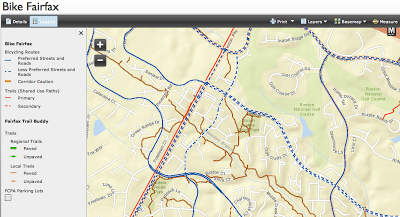 The Fairfax County Bike Program recently updated their Bicycle Program website. The site now includes the Bike Fairfax Interactive Map containing GIS layers from the printed route map along with several other map layers. The printed route map was an early goal of FABB and has been available for several years. FABB helped to create the map by advocating for funding and reaching out to local cyclists to map bicycle-friendly routes.
Users can choose from several background maps including streets, streets with topography, elevation, imagery, and a background image provided by National Geographic. One of the most interesting background maps is from OpenStreetMap, a public domain source created by the user community. It contains very detailed trail information in some areas.
The map layers are derived from the paper Bicycle Map but they also include more detailed trails shown in the Fairfax Trail Buddy layer. A sidewalk layer only appears at very large scales. An interesting feature is the ability to click on a map element and find out more information. Clicking on a road symbol brings up the meaning of the symbol (usually Preferred or Less Preferred), who maintains the facility (almost always VDOT), the speed limit, and the bicycle level of service category (A-F).
When the trail layer is queried, the width and surface are displayed along with who maintains the trail. We often find trails in poor condition and determining who is responsible for maintenance is difficult. Now we have a source to find out who to call. While the data are not complete, the interactive map is a great resource.
New McLean Bike Route Signage
 Fairfax County Department of Transportation has installed approximately 80 bike route signs providing directions and destination information throughout the downtown area of McLean. Dranesville Supervisor Foust was instrumental in getting funding for purchasing and installing the signs. McLean cyclists helped define the routes and determine sign locations.
Bike route directions point riders to the future Silver Line Tyson-McLean and West Falls Church Metrorail stations. The signage also directs cyclists toward the W&OD trail, Arlington and more. The signs are one of the first installations of wayfinding signage in Fairfax County based on new bicycle sign standards. They will set the standard for bicycle signage throughout the county.
Transportation Funding for New Bike Projects
On July 1 the general sales tax in Virginia increased to 6% as a result of the recently passed Transportation bill. The tax on gas was changed from a flat tax of 17.5 cents per gallon to a rate of 3.5% on the total purchase amount, effectively reducing the tax from 17.5 to 11.1 cents per gallon. User fees like gas taxes have never been enough to pay for our roads. We all pay for our roads whether we drive or not, and now we're all going to pay a little more.
The Transportation bill divides funds into regional projects (70% of funds) administered by regional authorities such as the Northern Virginia Transportation Authority and local funds (30%) administered by localities. Bike projects help reduce congestion and should be funded from both pots of money. Some people think otherwise. See a list of regional projects in Fairfax County. Contact your County Supervisor to find out what bike projects are being funded in your district.
Wednesday, July 17 - FABB Monthly Meeting
Wednesday, August 21, FABB Monthly Meeting
Labels: bike share, fabb newsletter, fairfax bike summit, interactive bicycle map, july-august, police, signs
Wednesday, May 22, 2013
Vienna bike route sign meeting May 28 - Updated May 23
 |
| Sign posted at W&OD Trail and Maple Ave |
A while back the Town Bicycle Advisory Committee developed a number of bike routes throughout the town and some signs went up on those routes. In our opinion there are not enough signs to lead a cyclist along the routes. There are a few signs but not the density that's needed to allow you to just follow the signs.
We've asked if any additional information about the meeting is available, including any proposals that will be discussed. It would be helpful to have that information before the meeting.
Update: We asked if there is more information about the bike route signage meeting and this was the response: "We're just asking the public if the current signage is working. If not, we'd like to find out what improvements are needed." Seems like there should be a bit more structure to the meeting but it sounds like it will be an open forum. If you'd like more info about bicycle signs and how they are used, see the Manual on Uniform Traffic Control Devices (MUTCD) chapter on bicycle wayfinding signage.
Labels: bicycle route network, signs, vienna bicycle advisory committee, vienna transportation advisory commission
Monday, December 21, 2009
New specs for bicycle traffic control devices
 The new version of the Manual on Uniform Traffic Control Devices (MUTCD) was recently released. See related posts at BikePortland, LAB, Wash Cycle, Rails to Trails, and VBF.
Major changes in Part 9. Traffic Controls for Bicycle Facilities include the new Shared Lane Markings, formerly called Sharrows. These have been used experimentally along some on-road portions of the Mt. Vernon trail in Alexandria. They can now be used without special permission. They indicate to motorists, on roads with a speed of 35mph or less, that bicyclists will be sharing the road.
 The "Bicycles May Use Full Lane (R4-11) sign" is another significant addition that "may be used on roadways where no bicycle lanes or adjacent shoulders usable by bicyclists are present and where travel lanes are too narrow for bicyclists and motor vehicles to operate side by side." It can be used with the Shared Lane Marking.
There are many locations in the county where these signs will help cyclists where there is no room for wide outside lanes or bike lanes. An example is on Old Courthouse Rd leading into Tysons. Bike lanes are located to the west. The road narrows as cyclists ride uphill approaching Freedom Hill Park where there are many mature trees and a steep bank that make widening the road very difficult. The new signs will indicate to motorists that cyclists belong in the center of the lane because the lane cannot be safely shared.
Another example is on Idylwood Rd between Hurst St and Idyl Ln. Cyclists coming from the W&OD Trail riding north to Tysons and McLean must take the lane and are often harassed by motorists. There are extensive utilities located adjacent to the road and the county estimates it will cost over $1,000,000 to provide paved shoulders. Shared Use Lane markings and Bicycles May Use Full Lane signs are a low cost measure that would help educate motorists about cyclists rights.
 Also of note are new bike route wayfinding signs that include destination information, mileage, and arrows. These are used extensively in Oregon and some other western states but were not part of the official manual until now. They can now be used for the planned bike route signs in McLean, on the Fairfax County Parkway Trail, and elsewhere.
A minor change that makes a great deal of sense concerns the use of "Bike Lane Ahead" and "Bike Lane Ends" signs. Use of these signs is no longer required, which could save money where there are either short sections of bike lanes or short gaps in existing bike lanes.


