
Silver Line opening day
 |
| New bike room customers with Charlie Strunk, county bike coordinator |
At around 11:30 a.m. the ribbon was cut at the south entrance to Wiehle station. Participants included US Department of Transportation Secretary Foxx, Virginia Governor McAuliffe, Congressmen Connolly and Moran, and several Virginia and Fairfax elected officials.
 |
| Cutting the ribbon at Wiehle-Reston East |
We exited again at Tysons Corner to check out the new Plaza at Tysons Corner Center (see construction camera). The direct connection from Tysons Corner station to the Plaza is not completed so we followed a circuitous route to street level then through Lord & Taylor. There were no bikes parked at the station racks but we expect them to get more use during the week.
 |
| Tysons Corner station |
We saw several passengers with bicycles at the Tysons and Reston stations. Metro is a great way to extend your cycling opportunities in the metro DC area.
Today was a major milestone for multimodal transportation in Fairfax County. It will be interesting to watch how travel patterns change over the next several years. We expect many more people in Fairfax to add Metro and biking to their transportation options.
 |
| First train riders entering Wiehle-Reston East |
 |
| Passing under Wiehle Ave |
 |
| Tysons Corner station bike racks |
 |
| Bird sculpture on The Plaza at Tysons Corner Center |
 |
| John Wetmore of Perils for Pedestrians |
 |
| Metro entrepreneur |
 |
| Bikes at the Wiehle station |
 |
| Free parking outside Wiehle bike room |
 |
| Bike coordinator Charlie Strunk and Bruce Wright of FABB inside Wiehle bike room |
 |
| Bruce and Kerie in Wiehle bike room |
 |
| Bike parking on south side of Wiehle station |
Labels: dulles metrorail, Tysons, wiehle station bike room, wiehle-reston east
Bike parking at Tysons Metrorail stations
We received these photos and info from Chris French, a FABB member who works in Tysons, about bike parking at the new Silver Line Metrorail stations along Route 7: |
| South side of Greensboro station |
In summary, there are 10 inverted U racks on the north and south side of each station, with the exception of the south side of the 'Spring Hill' station . There were only 4 at that location. Its possible they plan to put in more. So current count looks like a max of 40 bikes at Greensboro and a max of 28 at Spring Hill.
 |
| North side of Spring Hill station |
 |
| Wider sidewalks along Route 7 |
Labels: bike parking, dulles metrorail, Tysons
Biking and walking to Metrorail stations
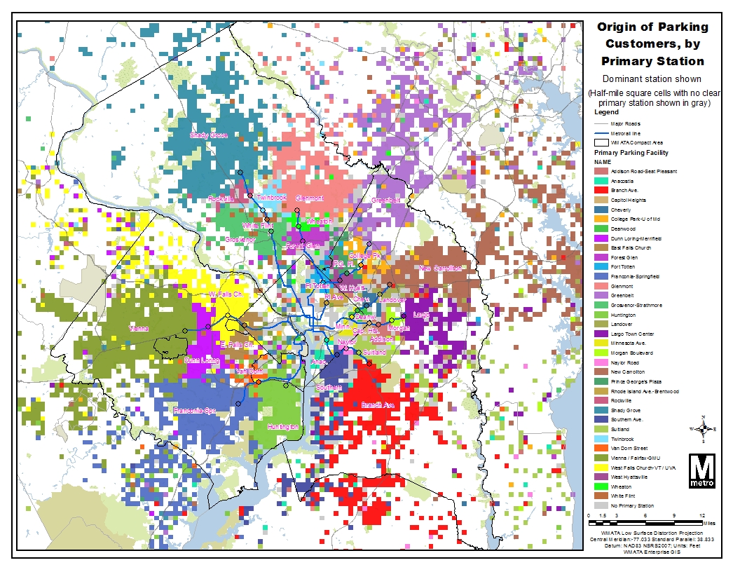
Dan Reed of Greater Greater Washington looks at the need to provide good biking and walking routes to Metrorail stations. He writes about a Metro study of distances people travel to Metro parking facilities. Many of the motorists at Metro parking lots live within a mile of the station. Given good bike and ped routes, most of those people could bike to the station and many could walk.In 2010 FABB's Tom Wyland wrote about a similar study done by Fairfax County, Travel patterns to the Herndon-Monroe Park and Ride lot.
A top goal of FABB is to ensure that residents have safe, convenient bicycle access to the Silver Line stations in Tysons and Reston. Current conditions at the Tysons stations are not good. All four stations are adjacent to major arterial roads (Routes 7 & 123). Other than the bike lanes on the Gallows Road leading into Tysons, there are no dedicated bike facilities in Tysons. While some of the Phase 1 Tysons Bicycle Master Plan facilities have been built, most have not. Bike access to the Wiehle Ave station in Reston is better, but some of the more important planned improvements will not be made until 2017 or later.
From the GGW article:
Meanwhile, 26 other stations serve "neighborhood parking" needs, attracting commuters who drive very short distances. Two-thirds of drivers at Forest Glen station come from within two miles, while 30% of drivers at Van Dorn Street, West Hyattsville and Fort Totten come from within one mile. These commuters could walk or bike instead, but many of these stations are located in a way that makes doing so hard, if not impossible.
Fort Totten is in the middle of a park, and while surrounding neighborhoods are fairly dense, there are very few street connections to them. West Hyattsville is surrounded by vacant lots. Van Dorn Street is hemmed in by rail yards, busy roads and the Beltway. Forest Glen actually has decent street connections, but people living south of the station have to cross the Beltway on a dark, dangerous pedestrian bridge.
As a result, people living near these stations feel like they have to drive there. This means more car traffic and more pollution, since cars produce the most emissions withinthe first few minutes of operation.
But poor pedestrian and bike access also restricts the capacity of a station to how many parking spaces it has. If those spaces are filled by the morning rush hour, that station is effectively closed to new riders until the evening. That might explain why stations like Forest Glen and West Hyattsville have some of the system's lowest ridership.
Labels: dulles metrorail, greater greater washington, planit metro, reston, Tysons
Biking to the Wiehle Ave Metro Station
The following article, Biking to the Wiehle Avenue Metro Station, was posted on the Reston Patch today. Note in the comments section that two of the first three commenters joke about hitting cyclists. I don't find it amusing: |
| Reston bike routes from county bike map |
Leading up to Bike to Work Day two years ago, I challenged our neighbors Del. Ken Plum and the Reston Association President Kathleen Driscoll to a commuter challenge from our neighborhood to the Reston Town Center.
I can remember waving at Ken as I passed him on the Wiehle Ave bridge; he was waiting at one of the traffic signals as I rode by on the trail. I beat Ken to the Town Center by a few minutes and we beat Kathleen, who took the connector bus, by about 20 minutes. For short trips bicycling is often faster than driving, especially when you consider the time to park and walk to your destination.
 |
| 2-mile radius around Wiehle station |
What are the best bike routes to the station? The W&OD Trail is located less than one-quarter mile from the north station entrance. There is a multi-use trail that connects the W&OD Trail to the station entrance, although it needs to be repaved and widened. It also needs to be extended north to Baron Cameron. Unfortunately the shared bus/bike lanes that were recommended as part of the Reston Metro Access Group report (see chapter 3) are not being constructed on the western entrance to the station. Better bike facilities are needed in the immediate station vicinity to avoid conflicts between cyclists, pedestrians, buses, and cars.
From the south, the new bike lanes on Soapstone Dr and Lawyers Road will connect most cyclists living south of the Toll Rd and east of Reston Parkway. Those cyclists can use neighborhood streets or connecting trails to reach Lawyers or Soapstone and ride to Sunrise Valley Dr. The existing mutli-use trail along Sunrise Valley Dr will soon be upgraded. Bike lanes on Sunrise Valley Drive, recommended in the RMAG report, are a longer term travel option. Most Reston residents should be able to safely ride to the station. See the Fairfax County Bike Route map for details.
For some Metro passengers traveling to Reston, getting from the station to their destination will be a challenge. Cyclists could leave their bikes overnight in the bike parking room and retrieve them on their way to work in the morning.
Bike sharing is another possibility and is a great last-mile solution and could be implemented in Reston. The Capital Bikeshare system is very popular in DC and many people are using it as a supplement or alternative to public transit. There are also other, less costly systems like ViaCycle at George Mason University.
Bike sharing stations could be scattered around denser parts of Reston including the Village Centers, major employers, and the Town Center. Users of Capital Bikeshare pay an annual membership fee of $70. Any trips of 30 minutes or less are free. I'm a member and when I use the system I time my trips to ensure they take less than 30 minutes. Daily membership is available for $7. See the CaBi website for details.
While it's difficult for some people living here in the suburbs to consider using bicycles for transportation, there are a few of us who rely almost solely on bikes to get around. Before you say that it's not a viable solution, why not give it a try. I'm willing to ride with anyone who wants to know a safe route to the station. Contact me at chairman@fabb-bikes.org.
Or consider riding on Bike to Work Day on Friday, May 17.
Labels: bike/car/bus challenge, dulles metrorail, wiehle ave
Bicycle: The Metro parking solution
That's the title Post editors gave to my letter to the editor about bike parking at Metro stations. It's a much better title than the online version, Metro present and future:That is correct only with respect to cars; all will have parking — bike parking. There will be space for several hundred bicycles, and more bike parking can easily be added, at a very small fraction of the cost of car parking, as was noted in the March 21 Metro article "Metro to lure bike-to-rail commuters."
Many residents around the region who live near Metro stations find that bicycling to the stations is quicker, less expensive and more convenient than driving to the station and parking. These short car trips also generate the most air pollution, since vehicles burn fuel less efficiently before properly warming up.
Hosh also asserted that Fairfax County "has outlined a bicycle path network . . ."
This is only partially correct. The county has developed a comprehensive bicycle master plan for Tysons Corner that includes recommendations for on- and off-road bicycle routes, bike parking and other end-of-trip facilities, and encouragement and education programs.
Many of these recommendations can be implemented before Metro arrives; we hope that the county hears the concerns of citizens and provides adequate funding and oversight to ensure cyclists can easily and safely access the new stations and other locations in Tysons Corner.
Bruce Wright, Reston
The writer is chairman of Fairfax Advocates for Better Bicycling.
Labels: bicycle parking, dulles metrorail, Silver line
Loudoun Supervisors to Vote on Bicycle-Pedestrian Items
We received the following notice from Pat Turner of BikeLoudoun. The Loudoun County Board of Supervisors will vote on two bicycle related items on Tuesday, December 7, with a public hearing on Monday, December 6:Next week there will be an important opportunity for you to support two bicycle resolutions that will be on the Board of Supervisors meeting agenda. Supervisor Andrea McGimsey, who has been a tireless advocate for better bicycle facilities in our county, is introducing the two items for consideration at the Dec. 7 Supervisors' meeting. The Public comment session occurs on the night before the meeting.
Action Item 7: Because federal funds directed specifically to bicycle and pedestrian projects will likely become available, the item directs the County Transportation staff to identify and prioritize a list of bicycle and pedestrian projects which can be made "shovel-ready." Jurisdictions who have a list of projects that can be initiated quickly will be more likely to receive these funds.
Action Item 8: This is a proposed plan for bike and pedestrian connectivity surrounding County metro stations. Access to the planned Loudoun metro stations on Routes 606 and 772 remains largely confined to vehicular access. Expanding bicycle and pedestrian facilities between and around metro stations will help decrease reliance on automobiles and further metro's benefits to the area along the Dulles corridor and beyond.
It is crucial that we have as many bicycle advocates as possible come to the public input session on Monday, Dec. 6, the night before the BOS meeting. The public session will be held at 7 p.m. in the Board Chamber, First Floor, at the County Government Building, 1 Harrison St., Leesburg. You can sign up to speak in advance by calling 703-771-5072 or 703-777-0200. Calls will be accepted until noon on Dec. 6.
Otherwise, you can sign up in the meeting room before the public session starts. Speakers are usually allowed only two to three minutes to comment. There will be no questions asked of you. So you see, your message need not be long--just express support for the bicycling items. If you wish, you can add your own personal comments about biking. It would be very impressive if we could have the room filled with bicyclists in their cycling jerseys.
We need to show the Board of Supervisors that bicycle accommodations and on-road bike facilities are important to us. Unless we actively support bicycling, the County may not approve these and other future bicycle plans.
Please forward this email to anyone else who may be interested. If you cannot come to speak on Dec. 6, please send comments to the entire Board of Supervisors via email at bos@loudoun.gov
Thanks for coming out to this important meeting.
(I'm sorry this is such short notice. The BOS agenda was just finalized)
Sincerely,
Pat Turner & Maria Nicklin
Co-Chairs, BikeLoudoun
www.bikeloudoun.org
"Advocating for Better Bicycling in Loudoun County"
Labels: bike loudoun, dulles metrorail, McGimsey; loudoun county
Phase II Silver Line stations

bicycling is a low-cost, efficient way to get there.
Covered, secure, conveniently located bicycle parking is needed at these stations. Bicycle parking at the existing Orange Line stations is already beyond capacity as evidenced by bicycles being parked along fences, posts or any fixed objects. It's unsightly and an inconvenience for bicyclists not to have adequate parking. The cost is minor compared to auto parking and the benefits are greater. Bicycle access to the bicycle parking locations is important and should be considered in all station designs. The parking should be located near the station entrance, not at a remote location.
Labels: dulles metrorail, Silver line
Dulles Rail public meeting
 This is a good opportunity to find out more about the Dulles Rail project. Changes are being proposed for several of the rail stations as part of the Phase 2 of the project, from the Reston Parkway station to Dulles Airport, ending at Route 772 in Loudoun County. A major change at the Dulles Airport station would move the station exit much further away from the airport terminal. This is also a chance to ask about bicycle accommodations at these stations.
From the Dulles Corridor Metrorail project:
Public Information Workshops will be held on Sept. 13, 14 on Proposed Design Updates to Phase 2 of the Dulles Corridor Metrorail Project
The Metropolitan Washington Airports Authority will hold two public information workshops to update the public on the latest design plans for the 11.6 mile section of Phase 2 of the Dulles Metrorail project which will be built from Wiehle Avenue on the eastern edge of Reston in Fairfax County to Route 772 in Ashburn in eastern Loudoun County.
Information will be provided on the six future Metrorail stations in Phase 2, including an alternative option for the Washington Dulles International Airport station. The other five Phase 2 stations will be located near: Reston Parkway; Herndon-Monroe; Route 28; Route 606 and Route 772.
The meetings are scheduled for:
Monday, September 13
6:00 p.m. to 8:00 p.m.
Sheraton Reston
11810 Sunrise Valley Drive
Reston VA 20191
Tuesday, September 14
6:00 p.m. to 8:00 p.m.
Loudoun Heritage Farm Museum
Claude Moore Colonial Farm
21668 Heritage Farm Lane
Sterling, VA 20164
The meetings will be held in open house format and will provide an opportunity to learn about and comment on the updates. If special assistance is needed, including a request for an interpreter, please call 571-265-2658 or TDD 711 by Friday, Sept. 10.
Information on the latest plans for Phase 2 was made available on the Dulles Metrorail Project website, www.dullesmetro.com, on September 2. Comments on these plans can be made online by visiting the website, www.dullesmetro.com after September 2 by clicking on the "Phase 2 Information" section. Written comments may also be emailed to Phase2Comments@dullesmetro.com or mailed to: Dulles Corridor Metrorail - Phase 2, c/o Cordell & Crumley, PO Box 2562, Reston, VA 20195.
The comment period ends October 1, 2010.
Labels: dulles metrorail, phase 2
Cross County Trail detour
We mentioned earlier that the Cross County Trail is closed at the Dulles Toll Rd. Large equipment involved in construction on the Silver line is blocking the narrow section under the bridge, next to Difficult Run. No detours were provided. The WashCycle just alerted us to a Sun Gazette article on a detour that will now be signed. According to the article:The work will be completed in September, and will remain in place for the duration of the closure.
When we asked park authority staff about the status of the project recently we were told that a detour was in the works and that signs had already been printed. While many cyclists already know about the planned route, it's great to see it will be signed and in place soon.
Labels: cross county trail, dulles metrorail
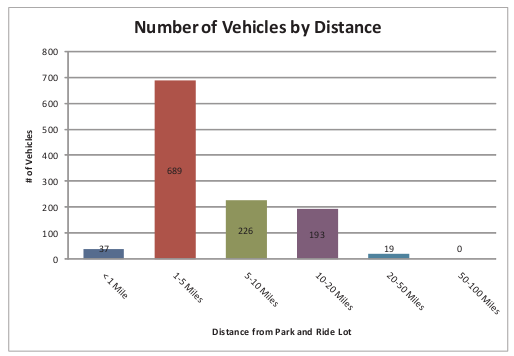
Travel patterns to the Herndon-Monroe Park and Ride lot
By Tom WylandNational government transportation surveys have shown that the vast proportion of short trips in the US are taken by personal motor vehicle. With that in mind, we took a look at some findings from a recent Fairfax County study which included the Herndon-Monroe Park & Ride (P&R). We were curious to see if many of the car trips to this facility were short enough to be easily replaced by bike trips.
With 1,745 free parking spaces, Herndon-Monroe is the largest P&R facility in the county without co-located rail service and was constructed at a cost of $20 million. The dedicated ramps at this facility allow eastbound drivers from the Dulles Toll Road direct access into the garage. From there, drivers can take frequent express buses to metro stations, the Pentagon, Dulles Airport or DC. The transit station also acts as a local community bus hub and will be expanded for the new Herndon-Monroe metro station. A Silver line station will be located here as part of Phase II of the project.
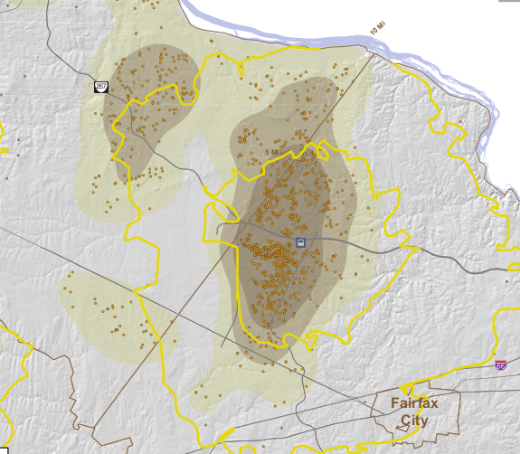
The 2008 study was performed to determine the starting locations of cars that park at the station. The results of the data reflect the two types of commuters: those who arrive from the west on the highway (from greater than 5 miles away, 38%) and those who drive on surface roads (0-5 miles, 62%). Looking at the close-up map, it is clear that many of that 62% share live within 2-3 miles of the facility, with a large cluster to the Southwest of the station (the median distance is 3.7 miles).

So why aren't more of the those living within five miles of the station walking or biking there? Here are some thoughts about why people drive to the station:
- Free Parking: Garage parking is free and plentiful.
- Poor North-South Connections: The bridge across the Dulles Toll Road at the station has no bicycle or pedestrian accommodations. The crossing of the Dulles Toll Rd on the Fairfax County Parkway trail is dangerous
- No Dedicated On-Road Bicycling Facilities: Sunrise Valley Dr has narrow travel lanes and the county bike map shows this as a less-preferred route for on-road bicycling.
- No Off-road Bicycling Connections: Even though the station is 0.5 miles from the heavily-biked Fairfax County Parkway and 1.5 miles from Washington & Old Dominion (W&OD) trails, there is no connection from these routes to the station. The sidepath on Sunrise Valley Dr is mostly a narrow sidewalk.
- Poor access to the West of the Station: Missing links in the existing facilities make biking and walking less attractive from this direction where most of the short-distance drivers are located.
Instead the Herndon-Monroe transit station provides abundant free car parking and easy road access for local residents with no improvements for accessing the facility by bike or foot. The redevelopment of this site as part of the Silver line expansion is a chance to reverse this trend.

Labels: dulles metrorail, herndon-monroe, Silver line
Cross County Trail closed at Dulles Toll Rd
 Due to construction of the Silver line, the Cross County Trail (CCT) is closed at the Dulles Toll Rd and Difficult Run. At this point the trail passes under the Toll Rd and is adjacent to Difficult Run. There is very little room to maneuver construction equipment under the existing Toll Rd bridge. The equipment is being used to build a new bridge for the Silver line track.
There were plans to close the trail earlier this year. At that time we were told it would be closed until November. Since then there has been plenty of time for the county and the Metropolitan Washington Airports Authority (MWAA), which operates the Toll Rd and is constructing the Silver Line, to develop a detour. This is a heavily used trail that should never be closed without a detour. Would we close a major road with no options for motorists who travel on that road?
As we noted in the earlier post about the closure, there is a possible detour that requires riding on the Beulah Rd bridge across the Toll Rd. As a commenter noted earlier, Beulah Rd is a heavily traveled road, and the bridge over the Toll Road is narrow with no trail or sidewalk. Only experienced cyclists should use this route.
If you're headed north there is a dirt path leading from the CCT to Squaw Valley Dr. Take Squaw Valley Dr to L on Lozano Dr to L on Beulah Rd. Continue on Beulah Rd across the Toll Rd to L on Days Farm Dr just after the bridge. There are tennis courts located at the bottom of Days Farm Dr where a trail connects to the CCT. Map of possible detour.
To comment on the lack of a detour at this location contact the Park Authority trails coordinator. You can also complain to MWAA.
Update: MORE has a thread in their forum on riding the detour.
Labels: cross county trail, dulles metrorail
Cross County Trail closed at Dulles Toll Rd
 Thanks to The Wash Cycle we learned that the Cross County Trail is closed (or will soon be, I haven't checked it) at the Dulles Toll Rd. until November 2010. Large equipment used for construction of the Dulles Corridor Metrorail Project will block the trail at the Difficult Run bridge. Unlike similar construction at the W&OD Trail and the Dulles Toll Rd, there will be no detour provided. Read the County Park Authority news release Temporary Construction Closure Set For Northern CCT.
Whenever a major trail is closed a detour should be provided. In this case it would be difficult to provide a detour under the Toll Rd bridge due to limited space and the presence of the river adjacent to the trail. However, if this were the W&OD Trail, we're confident that the N. Va. Regional Park Authority would find a way to create a detour.
One option if you're headed north is to head east to Squaw Valley Dr. We've heard there is a dirt path leading from the CCT to Squaw Valley but we've never checked it. Take Squaw Valley Dr to L on Lozano Dr to L on Beulah Rd, cross the Dulles Toll Rd, continue on Beulah to L on Days Farm Dr just after the bridge. There are tennis courts located at the bottom of Days Farm Dr with a trail that connects to the CCT. We'll try to check out this rate as soon as we can. See Google map of the area. Map.
Update: According to the map Cross County Trail - Dulles Highways to W&OD Trail on the Reston Paths website, there are connections to Squaw Valley Dr and Days Farm Dr.
Labels: cross county trail, dulles metrorail
Bicycle access to planned Herndon-Monroe Metro station
Cyclists in the Reston-Herndon area are encouraged to attend a discussion of future changes around the planned Herndon-Monroe Metro station. The meeting is one of a series to discuss possible changes to the county Comprehensive Plan for the area around the three Reston/Herndon stations. It will be held at Langston Hughes Middle School in Reston from 9 a.m. to noon. See the Reston Master Plan Special Study website for more information.Many cyclists currently commute to the Herndon-Monroe bus station. Sunrise Valley Drive has narrow lanes, no shoulder and poor line of sight. The road needs dedicated bicycle facilities (wide curb lanes or bike lanes). There should also be good bicycle connectivity to Fairfax County Parkway and the W&OD Trail, as well as a bicycle crossing of the Dulles Toll Road to connect Herndon with the are to the south. Additional covered bicycle parking will be needed as well, including bike lockers.
Labels: dulles metrorail, herndon, herndon-monroe
W&OD Trail detours and night closure
 The Dulles Corridor Metrorail Project announced yesterday that there will be detours and occasional night closures of the W&OD Trail for the next nine months at the Dulles Toll Road underpass between Sunrise Valley Drive and Sunset Hills Road. We're trying to find out more details about the detours or closures. Closure of the trail, even at night, will have a major impact on bicycle commuters in this part of the county:
Users of the Washington and Old Dominion (W&OD) Trail near Reston will experience shifts and detours in a short section of the trail for the next nine months. The periodic shifts will be caused by construction of a bridge over the trail by the Dulles Corridor Metrorail Project. Construction crews will build a bridge above the trail in the middle of the Dulles International Airport Access Highway between Wiehle Avenue and Hunter Mill Road. The bridge will carry the future Metrorail line over the W&OD Trail. The Airport Access Highway is the toll-free lanes that carry traffic to and from the Washington Dulles International Airport in the median of the east and west bound Dulles Toll Road lanes.
The work will start this month and is scheduled to end in mid-2010. The affected area is along the trail's mile marker 16 (see map). In addition, the trail will close temporarily some nights in late Spring 2010, when steel girders will be installed. Brief periodic closures also will be necessary throughout construction when equipment is moved into place. All users of the trail should watch for warning signs alerting shifts in the trail path, as well as equipment and materials in the adjacent slopes of the median.
If you have any construction-related emergencies, please call the Dulles Corridor Metrorail Project Hotline at 877-585-6789. For other information, please visit our project website or call 703-572-0506.
Labels: dulles metrorail, W and OD Trail
Dulles Rail project construction hotline
Construction on the Dulles Rail project has also begun. The first phase of the project is relocation of utilities along Route 7. There is a service road along Route 7 between the Dulles Toll Road and Route 123 that cyclists use. There is also a sidewalk that is used by service workers and many office employees during the day. Due to the recent construction, both the service drive and the sidewalk on the south side are completely blocked. Would VDOT allow a major road to be closed with NO access for traffic? They would provide a detour. Why don't the same rules apply to non-motorized traffic.Dulles Transit Partners, the primary project contractor, has set up a hotline to report problems associated with the construction: 877-585-6789. If you use the route above, or any other route that is blocked by project construction, you can call the above number to report the problem. I called about the lack of a detour on the Route 7 construction and was given a report number and I'll be checking in a week or so to see what is being done to allow cyclists and pedestrians to get around the construction.
Labels: dulles metrorail


