
Thursday, September 5, 2013
Biking and walking to Metrorail stations
Dan Reed of Greater Greater Washington looks at the need to provide good biking and walking routes to Metrorail stations. He writes about a Metro study of distances people travel to Metro parking facilities. Many of the motorists at Metro parking lots live within a mile of the station. Given good bike and ped routes, most of those people could bike to the station and many could walk.In 2010 FABB's Tom Wyland wrote about a similar study done by Fairfax County, Travel patterns to the Herndon-Monroe Park and Ride lot.
A top goal of FABB is to ensure that residents have safe, convenient bicycle access to the Silver Line stations in Tysons and Reston. Current conditions at the Tysons stations are not good. All four stations are adjacent to major arterial roads (Routes 7 & 123). Other than the bike lanes on the Gallows Road leading into Tysons, there are no dedicated bike facilities in Tysons. While some of the Phase 1 Tysons Bicycle Master Plan facilities have been built, most have not. Bike access to the Wiehle Ave station in Reston is better, but some of the more important planned improvements will not be made until 2017 or later.
From the GGW article:
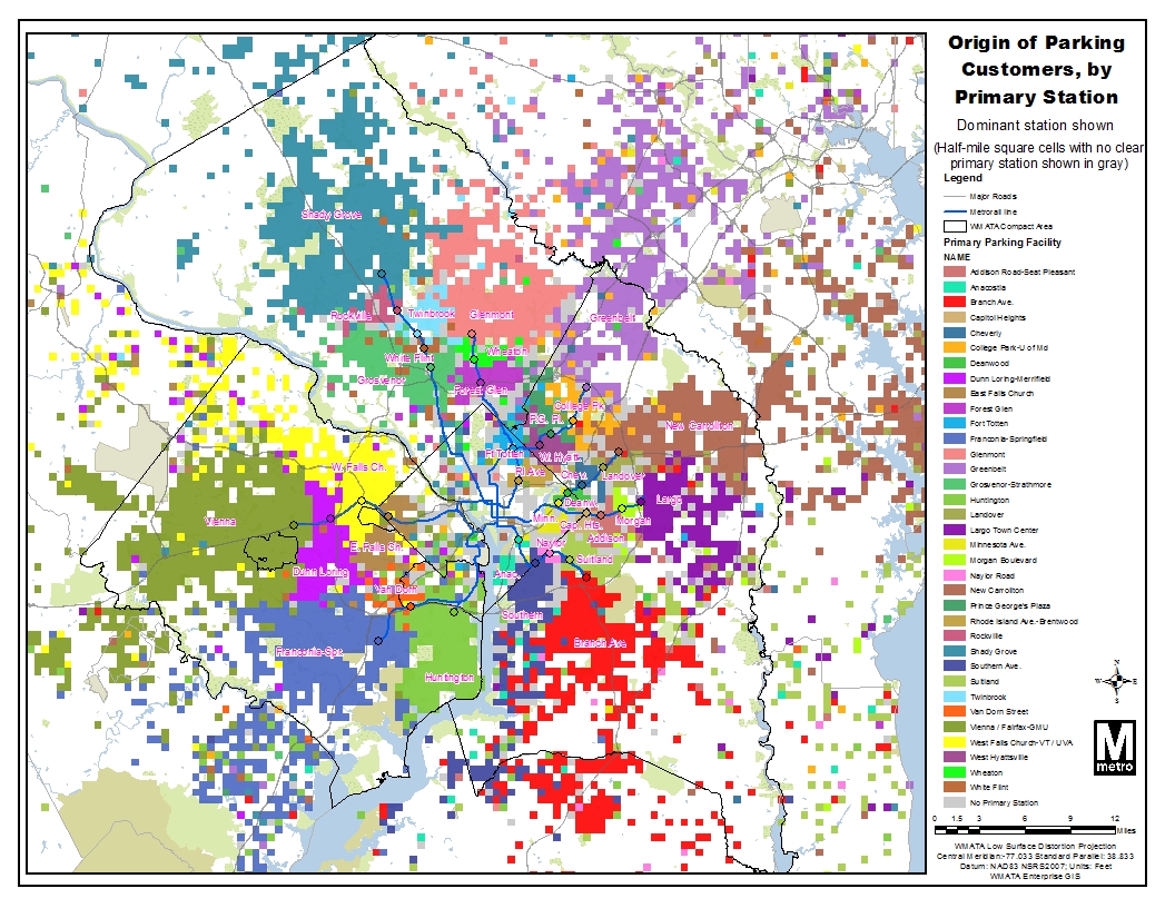
Meanwhile, 26 other stations serve "neighborhood parking" needs, attracting commuters who drive very short distances. Two-thirds of drivers at Forest Glen station come from within two miles, while 30% of drivers at Van Dorn Street, West Hyattsville and Fort Totten come from within one mile. These commuters could walk or bike instead, but many of these stations are located in a way that makes doing so hard, if not impossible.
Fort Totten is in the middle of a park, and while surrounding neighborhoods are fairly dense, there are very few street connections to them. West Hyattsville is surrounded by vacant lots. Van Dorn Street is hemmed in by rail yards, busy roads and the Beltway. Forest Glen actually has decent street connections, but people living south of the station have to cross the Beltway on a dark, dangerous pedestrian bridge.
As a result, people living near these stations feel like they have to drive there. This means more car traffic and more pollution, since cars produce the most emissions withinthe first few minutes of operation.
But poor pedestrian and bike access also restricts the capacity of a station to how many parking spaces it has. If those spaces are filled by the morning rush hour, that station is effectively closed to new riders until the evening. That might explain why stations like Forest Glen and West Hyattsville have some of the system's lowest ridership.
Labels: dulles metrorail, greater greater washington, planit metro, reston, Tysons
Saturday, December 22, 2012
Converting trips to Metro stations from car to bike/walk trips
In recent years WMATA has improved bike parking at many of their stations. However, bike/ped access to the stations from surrounding areas has not often been a high priority. That is changing. From the PlanIt Metro blog:
In our effort to improve safety, access and sustainability, Metro is expanding our understanding of bike and pedestrian barriers faced in commuting to our Metrorail stations. Over the past several years, we have focused our bike and pedestrian project planning and implementation efforts on improvements we can make to our station areas such as, installing bike racks or constructing pedestrian improvements. Now, we’d like to expand the envelope and develop a list of access needs beyond our own boundaries and work with our jurisdictional partners to make needed improvements.
One way we are doing this is by gaining a better understanding of where auto commuters come from when they drive to our stations, and zeroing in on areas where we see a good deal of auto access to determine if there are barriers to walking or biking to the station.
The map at right (full version) shows auto-to-station “hot spots” around the Forest Glen station, to pick one example, locations from which clusters of customers drive and park at Metro. According to the 2007 Metrorail Passenger Survey data, many customers drive from within a 1-3 mile radius; some are even closer. So why are so many people from this area driving? In our 2010 Bicycle and Pedestrian Master Plan, we teased out some of the more broad-based reasons why people drive rather than walk or bike – now we’d like to explore each station’s local conditions and see what can be done to improve walk and bike access.
 |
| Heat map showing short-distance parking access at Forest Glen station, which indicates good opportunities for pedestrian and bicycle access (click for full map) |
The map at right (full version) shows auto-to-station “hot spots” around the Forest Glen station, to pick one example, locations from which clusters of customers drive and park at Metro. According to the 2007 Metrorail Passenger Survey data, many customers drive from within a 1-3 mile radius; some are even closer. So why are so many people from this area driving? In our 2010 Bicycle and Pedestrian Master Plan, we teased out some of the more broad-based reasons why people drive rather than walk or bike – now we’d like to explore each station’s local conditions and see what can be done to improve walk and bike access.
Labels: Metro, planit metro, wmata


