
I-66 Bicycle and Pedestrian Trail Update

Reminder: VDOT Meeting on Thursday

Labels: Fairfax City, i-66 outside the beltway, vdot, vienna
Upcoming Transform 66 Outside the Beltway Public Hearing
 |
| VDOT district office. |
- Commuter parking garage at Fairfax Corner
- George Snyder Trail in Fairfax City
- Jermantown Road (widen bridge over I-66 in Fairfax to four lanes)
- Monument Drive bridge pedestrian improvements in Fairfax
- Rt. 50/Waples Mill Road intersection improvements in Fairfax
- Poplar Tree Road (widen bridge over Route 28 in Fairfax to four lanes)
- Lee Highway pedestrian improvements in Fairfax
- Nutley Street Southwest multi-use trail to Metro in Vienna
Labels: commonwealth transportation board, Express Mobility Partners, i-66 outside the beltway, vdot
Upcoming I-66 Outside the Beltway Public Hearings


Labels: i-66 outside the beltway, i-66 parallel trail, public meeting, vdot
Upcoming Providence District Meeting on I-66
 |
Labels: i-66 outside the beltway, i-66 parallel trail, providence district
VA Legislators Support Improved I-66 Parallel Trail
Several VA legislators recently sent a letter to Aubrey Laine, the Virginia Secretary of Transportation, to express their concerns about the design of the I-66 parallel trail. The trail will be included as part of the widening of I-66 outside the Beltway. Senator Scott Surovell spearheaded this effort, working with FABB and other advocacy groups. Thank you Senator Surovell and thanks to your Senate and House colleagues! Please consider sending a thank you note to these officials.The Washington Post reported on the letter and the response from VDOT in the online article Virginia lawmakers oppose plan to sandwich I-66 trail between a sound wall and traffic. The article includes a link to an edited version of the simulation video produced by FABB. The original version is below.
From the Post article:
The Virginia Department of Transportation proposal squeezes the walking path between the highway and the concrete wall that serves as a buffer between traffic noise and adjacent neighborhoods. A jersey barrier and fence would separate trail users and traffic.
“We believe this is an insufficient design,” says a letter addressed to transportation secretary Aubrey Layne and signed by 18 members of the Virginia General Assembly. “I-66 Trail users will be closely sandwiched between a sound wall and traffic exposing them to concentrated quantities of car exhaust, noise pollution and road debris.”
Here is VDOT's response in the Post article.
Organizations that supported the letter and legislators who signed on:
(1) The Virginia League of Conservation Voters;
(2) The Virginia Sierra Club;
(3) The Southern Environmental Law Center;
(4) The Virginia Bicycling Federation;
(5) The Virginia Cycling Association;
(6) The Washington Area Bicyclist Association (WABA);
(7) The Coalition for Smarter Growth;
(8) The Rails-to-Trails Conservancy;
(9) Mid Atlantic Bicycle Racing Association (MABRA)
(10) The Fairfax Alliance for Better Biking;
(11) Active Prince William;
(12) The Sierra Club – Mt. Vernon Chapter;
(13) The Alexandria Bike & Pedestrian Advisory Committee;
Senator Scott A. Surovell, 36th District, Fairfax, Prince William, & Stafford Counties
Senator Jeremy McPike, 29th District,Manassas, Manassas Park, & Prince William County
Senator Barbara Favola, 31st District, Arlington, Fairfax, & Loudoun Counties
Senator Janet D. Howell, 32nd District, Arlington & Fairfax Counties
Senator Jennifer T. Wexton, 33rd District, Fairfax & Loudoun Counties
Senator David F. Marsden, 37th District, Fairfax County
Delegate Ronald A. Villanueva, 21st District, Chesapeake & Virginia Beach
Delegate Richard C. Sullivan, Jr. 48th District, Arlington & Fairfax Counties
Delegate J. Randall Minchew, 10th District, Clark, Frederick, & Loudoun Counties
Delegate Sam Rasoul, 11th District, Roanoke
Delegate Kenneth T. Plum, 36th District, Fairfax County
Delegate Kaye Kory, 38th District,Fairfax County
Delegate Vivian E. Watts, 39th District, Fairfax County
Delegate Mark H. Levine, 45th District, Alexandria, Arlington & Fairfax Counties
Delegate Charniele L. Herring, 46th District, Alexandria
Delegate Patrick A. Hope, 47th District, Arlington County
Delegate James M. LeMunyon, 67th District, Fairfax & Loudoun Counties
Delegate Jennifer M. Boysko, 86th District, Fairfax & Loudoun Counties
Labels: i-66 outside the beltway, i-66 parallel trail, i-66 trail video
Comment on I-66 Parallel Trail by June 30th
 |
| FABB produced simulation of I-66 Trail. |
- Comments should be sent to Transform66@VDOT.Virginia.gov.
- You can also send messages to The Honorable Aubrey L. Layne, Jr., Virginia Secretary of Transportation through the Governor’s office at https://governor.virginia.gov/constituent-services/Communicating-with-the-governors-office.
- The project significantly benefits northern Virginia by connecting adjoining neighborhoods and future transit facilities. This not only facilitates daily multimodal commutes to work but also can help reduce congestion by allowing citizens to use bikes for short trips for local errands and shopping.
- The proposed trail expands Fairfax County's bike network, providing an extensive new east-west bike/pedestrian route plus connections to the W&OD trail, the Cross County Trail, and others.
- The creativity in developing many of the underpasses, grade separated, and other crossings to help cyclists and pedestrians on the trail safely traverse intersections. Hope that this and the creativity applied to the Route 7 trail bridge will continue to be applied to all of the segments of the I-66 trail.
- The proposed installation of bike counters to gather data on usage will be very welcomed, especially if improvements to the trail are made to insure that it is an appealing, safe, and healthy transportation option.
- 11 access points to the trail are a good start to increasing connectivity and encouraging use.
- The potential noise impacts on trail users could be high on those sections between the sound wall and the highway. Beyond exposing the users to the dangers of high decibel noise, cyclists and pedestrians may have difficulty hearing the bells, horns, and shouts of other users passing them. The noise impact on users inside the sound wall should be analyzed before construction begins and the results should be used by VDOT in selecting the safest and healthiest location for placement of the multiuse trail.
- The exposure of trail users to pollution when the trail is between the sound wall and highway not only may have negative health impacts on regular users but may discourage many from using the trail. At a minimum, the pollution levels and health effects should be analyzed and made available to potential users. EPA research concludes placing a shared use path outside of the sound wall will improve air quality by 50%. .
- The current plans have the trail on the same grade as the highway. With only a concrete and fence barrier and a 12-foot shoulder separating trail users from I-66 traffic, the proximity to traffic may discourage some people because of perceived dangers from the nearby motor vehicles.
- The trail inside the wall is very exposed and with no natural buffers to protect users from weather and noise. During the summer when heat is radiating off the highway and the trail’s pavement, the absence of shady sections to provide some relief could discourage trail use.
- The trail would benefit from additional access points through the sound wall. This will improve accessibility and provide users a sense of security knowing that they have more options to get off the trail if needed. While access will be provided at many of the overpasses, Jermantown Road, near Yoenas Park and Dunn Loring at Gallows Road should be provided for connectivity to transit, recreation locations and shopping destinations.
- Our understanding is that in many areas the trail will only be 8-feet to 10-feet wide with 2-foot shoulders. We hope that, with grade separation and other improvements that the trail can be widened where possible to accommodate users, especially when utility vehicles using the trail as a service road are present.
- A major concern is that if the trail is not improved it will be so unappealing that it will not be used. An underutilized trail could then be used by opponents of trails and similar multimodal transportation options to then argue against them, seriously undermining VDOT goals for reducing congestion.
Labels: i-66 outside the beltway, i-66 parallel trail, vdot
I-66 Trail Simulation Video Updated
 |
| Revised Trail Simulation includes fence on top of barrier. |
The primary changes are that there will be a fence instead of vanes on top of the concrete barrier separating the trail from the highway. Also, the concrete barrier is now planned to between 32 and 36 inches high rather than just two feet.
Labels: i-66 outside the beltway, i-66 parallel trail, vdot
I-66 Trail: Air Quality Questions

Labels: air quality, i-66 outside the beltway, i-66 parallel trail, sound walls
FABB’s I-66 Trail Simulation Shows Plan's Shortcomings
 |
| Biker's view of the I-66 parallel trail, which will be 8' - 10' wide with 2' shoulders. |
Labels: i-66 outside the beltway, i-66 parallel trail, vdot
Three Meetings in June on I-66 Bike/Pedestrian Trail
 |
| I-66 Outside the Beltway Project map. |
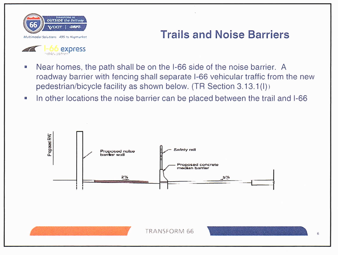
- For about 16 of the project’s 22 miles the current plan places the trail when it passes near homes on the highway side of the noise barrier/sound wall.
- In these locations the trail will only be separated from traffic by a two-feet tall roadway barrier topped by fencing.
- In these locations exposure to noise, pollutants, buffeting from traffic, and weather (the path appears to lack natural cover from trees to protect against sun and wind) will affect the quality of the user experience on the trail.
- The height of a separate grade for the trail, if any, has not determined.
- The 8-feet to 10-feet wide trail will be used as a service road for utility vehicles, and when these trucks are present, trail traffic will be constricted.
- There are only 11 access points to the trail through the sound barriers planned in select local neighborhoods, which may not be sufficient for safety and ease of use.
- The plan relies on ambient lighting from the roadway to illuminate the trail. Public input on areas on where additional lighting might be appropriate would be helpful
- Monday, 12 June, Oakton High School, 2900 Sutton Road, Vienna
- Wednesday, 14 June, Stone Middle School, 5500 Sully Park Drive, Centerville
- Thursday, 15 June, Pine Branch Elementary School, 8301 Linton Hall Road, Bristow
Reminder: Monthly Meeting Next Week Features Fundraiser and VDOT Briefing

Labels: i-66 outside the beltway, mosaic, vdot
I-66 Parallel Trail included in Final RFP
On July 29 VDOT issued the final Request for Proposals (RFP) for the I-66 Outside the Beltway project. The RFP includes detailed requirements for construction of the paved trail parallel to I-66. From the beginning of the project, FABB's position has been that if the project is constructed, the parallel trail that is included in the county's Comprehensive Plan and the Bicycle Master Plan should be included. |
| I-66 Parallel Trail Map |
FABB also advocated for inclusion of bike counting devices on the trail. VDOT has detailed counts of existing motorized traffic and we felt they should do the same for bikes. Those counters are now included in the RFP. Mile markers and wayfinding signs will also be included. All ramp crossings will be grade-separated.
Fairfax County will still be responsible for building parts of the trail that are not part of the I-66 project, which unfortunately includes significant segments at the Vienna Metro station and and the Fair Oaks area. Your support for these facilities will be needed in the future. We will continue to monitor the project to ensure the trail is completed according to the plans.
From the Final RFP, Vol. III, Final Technical Requirements and Attachments (Exhibit C) as referenced on the Transform 66 PPP page. We've highlighted important aspects of the requirements:
A. The Developer shall design and construct the Project to include proposed pedestrian, bicycle and equestrian facilities within the Project corridor, as identified in the RFP Conceptual Plans. The Developer shall not preclude the future design and construction of pedestrian, bicycle, and equestrian facilities currently being planned or anticipated.
B. Existing pedestrian and bicycle access on facilities shall be maintained to the maximum extent possible throughout construction as per the MUTCD and the Virginia Work Area Protection Manual. Any temporary pedestrian or bicycle facility closure request shall be submitted in writing twenty-one (21) days in advance to the Department for review and approval. Advance notification of closures shall be provided to the public similar to scheduled roadway closures.
C. New bicycle and pedestrian path facilities and modifications to existing bicycle and pedestrian path facilities shall be designed in accordance with the standards and specifications set forth in Attachment 1.5. All new bicycle and pedestrian path facilities intersecting I-66, the associated Interstate ramps, or other roadway facilities as depicted on the RFP Conceptual Plans shall be grade separated (over or under) unless otherwise approved by the Department.
D. Where a box culvert is replaced along a proposed or existing trail, the new culvert barrel carrying the path shall have sufficient width and vertical clearance to accommodate the shared-use path and a handrail adjacent to the stream. In lieu of this, a separate barrel may be solely dedicated for shared- path use. The walking surface of the path shall be located above the five-year stormwater level. Where the path also serves as an equestrian trail, the vertical clearances shall be increased accordingly. Lighting shall be required for all bicycle and pedestrian path underpass structures and facilities. This lighting shall be installed in accordance with the VDOT Traffic Engineering Design Manual.
E. The Developer shall conduct coordination meetings with all local jurisdictions and the Department to ensure existing and planned pedestrian, bicycle and equestrian facilities are identified along the Project corridor. Any planned facility that is not constructed with this project shall not be precluded in the future. For locations where new bridge overpasses are proposed to widen existing bridges with end spans that contain slope protection, the new bridge shall not be reduced in length and the new end span shall not preclude shared- use path placement.
F. The Developer shall coordinate with the Department and local jurisdictions on the design, maintenance of traffic and construction staging of the bicycle and pedestrian facilities within the Project limits.
G. Concrete and asphalt pavement designs for sidewalks and shared use paths shall be in accordance with Attachment 3.7. If a locality wants a stone dust surface on a facility, the Developer shall coordinate obtaining a maintenance agreement for the Department with the Locality. The specifications for the stone dust surface shall be approved by the Department.
H. The Developer shall design and provide drainage for any new independent pedestrian or shared-use path bridge or underpass structure. Drainage scupper grates on bridges and drainage grates in underpass structures shall be located within the 2-foot shoulder of the path unless otherwise approved by the Department. All drainage grates shall be bicycle friendly and meet ADA requirements. All drainage grate installation orientation shall prevent bicycle or pedestrian encumbrance.
I. The Developer shall design a shared use path parallel to I-66 that is consistent with the RFP Conceptual Plans. Where proposed noise barriers are to be located near homes, the path shall be on the I-66 side of the noise barrier. In addition, a roadway barrier with fencing shall separate I-66 vehicular traffic from the new pedestrian/bicycle facility.
J. Where possible, utility manholes should be located outside of any pedestrian areas (sidewalks, paths, etc.). If necessary, utility access manholes may be located within the 2-foot shoulder of the 10-foot shared use path. Where manholes are located within a sidewalk or shared use path, the manhole covers must be ADA compliant.
K. Access points to the shared use path parallel to I-66 shall be provided at approximately half mile increments. These locations may be co-located with other access needs to reduce the breaks in the sound barriers. The Developer shall coordinate with adjacent and nearby communities and local jurisdictions regarding the locations and design of each access point. Possible access points are in the vicinity of the locations listed below:
1. Braddock Rd at NW Quadrant of Route 28 Interchange. Underpass for connection to future trail to Route 28 north.
2. Audrey Dr (Cabells Mill Development, Centreville).
3. Connect to the standard turn at the end of Veronica Rd (Cabells Mill Development, Centreville).
4. West side of Stringfellow Rd connection to Park & Ride Lot and street crossing to east side of street trail.
5. Fair Lakes Shopping Center (behind Target).
6. East Market Shopping Center (behind Whole Food Market).
7. Existing trail from Waples Mill Rd (NE Quadrant of US 50 Interchange).
8. Arrowhead Dr/Rosehaven St (SW quadrant of Route 123 Interchange).
9. Bushman Dr (just east of tennis courts property).
10. Cedar Lane north side connection to I-66 parallel trail.
11. Connection to west bend of Yeonas Drive (west of Southside Park).
The above access points are shown on the RFP Conceptual Plans and the Bicycle/Pedestrian Concept Feasibility Study exhibits.
L. Mile marker and wayfinding signs shall be incorporated into the design.
M. Existing trails impacted by the Project shall be replaced.
N. The Developer shall provide 8 permanent non-motorized traffic counters composed of combined bicycle detector loops and passive infrared sensors. The location of counters shall be proposed by the Developer and approved by the Department. The infrared sensors shall be enclosed in a vertical post. The posts should have a 2-foot clearance from the path where possible. The proposed continuous count equipment and vendor shall be approved by the Department.
Each counter shall be able to:
1. Count both pedestrians and cyclists;
2. Differentiate between pedestrians and cyclists;
3. Measure the direction of travel of both pedestrians and cyclists;
4. Provide for automatic remote transmission of data via a modem;
5. Provide for in-field transmission of data wirelessly to a field computer;
6. Record count data at 15-minute intervals, 24 hours a day, 365 days a year;
7. Provide a detection height of 24 inches to 36 inches (for infrared sensor);
8. Operate in temperatures from -30 degrees Fahrenheit to 100 degrees Fahrenheit;
9. Be waterproof; and
10. Provide a wood post housing for natural settings or a metal vandal resistant post for urban settings.
Software used for transmittal and storage of data shall be able to:
1. Provide customizable alert system for missing or unusual data;
2. Provide the ability to combine data from multiple counters;
3. Provide the ability to record site description data;
4. Provide an estimate of counter battery levels;
5. Provide a data transmission subscription for each counter;
6. Provide the ability to create multiple viewer accounts; and
7. Provide the ability to view, edit, and create reports.
Labels: i-66, i-66 outside the beltway, i-66 parallel trail, transform66


