Wednesday, January 4, 2017
FHWA Publishes the Bike Network Mapping Idea Book
Federal Highway Administration Bicycle and Pedestrian Program recently published an excellent reference for communities planning to create or update bike route maps, the Bike Network Mapping Idea Book:
This resource highlights ways that different communities have mapped their existing and proposed bicycle networks. It shows examples of maps at different scales, while also demonstrating a range of mapping strategies, techniques, and approaches. Facility types represented on the respective maps and legends are each different because they represent a community’s unique context and needs.
 |
| From University of North Carolina's bike map |
Labels: bicycle route map, bike map, fhwa
Thursday, March 17, 2016
FHWA workbook on creating bike facilities during repaving projects

From the report:
Installing bicycle facilities during roadway resurfacing projects is an efficient and cost-effective way for communities to create connected networks of bicycle facilities. This workbook provides recommendations for how roadway agencies can integrate bicycle facilities into their resurfacing program. The workbook also provides methods for fitting bicycle facilities onto existing roadways, cost considerations, and case studies. The workbook does not present detailed design guidance, but highlights existing guidance, justifications, and best practices for providing bikeways during resurfacing projects.
 |
| Soapstone Dr before road diet |
 |
| Soapstone Dr after road diet |

Labels: fhwa, lawyers road, repaving, resurfacing, soapstone drive
Monday, November 2, 2015
Participants still needed for FHWA study on bicycle signs and signs

I recently participated in the study. Participants are shown a road with bike lanes at an intersection. You will be asked your opinion about several bicycle directional signs and signals. It's a painless process and you are paid for your time. The study will likely continue through November.
From FHWA:
EARN CASH AND HELP RESEARCHERS MAKE BICYCLING SAFER!
We are currently researching the design and implementation of bicycle traffic signals and signs intended to improve the safety of the bicyclist when at an intersection.
We really value your opinion as a bicyclist.
Study Information
What: Research study on bicycle traffic signs and other transportation studies
Where: Turner-Fairbank Highway Research Center – 6300 Georgetown Pike, McLean, VA 22101
Requirements: At least 18 years of age with a valid driver’s license and must bike regularly (at least 2 times a week)
We are currently researching the design and implementation of bicycle traffic signals and signs intended to improve the safety of the bicyclist when at an intersection.
We really value your opinion as a bicyclist.
Study Information
What: Research study on bicycle traffic signs and other transportation studies
Where: Turner-Fairbank Highway Research Center – 6300 Georgetown Pike, McLean, VA 22101
Requirements: At least 18 years of age with a valid driver’s license and must bike regularly (at least 2 times a week)
A typical study lasts 1 – 2 hours.
How to sign up: Call or email us: (202) 493-3335 HCS.Research@dot.gov
How to sign up: Call or email us: (202) 493-3335 HCS.Research@dot.gov
Labels: bicycle signals, fhwa, turner-fairbanks highway research center
Thursday, October 15, 2015
FHWA study on bicycle traffic signals needs your help
According to the study team, "We usually offer a wide range of times throughout the day and sometimes on Saturdays as well. We should be starting the project this upcoming Wednesday October 21st and will continue it into November."
The Center is located on Georgetown Pike adjacent to the CIA. It is possible to bike there via McLean to the paved shoulder on Route 123 to Chain Bridge Rd to Georgetown Pike.
From FHWA:
EARN CASH AND HELP RESEARCHERS MAKE BICYCLING SAFER!
We are currently researching the design and implementation of bicycle traffic signals and signs intended to improve the safety of the bicyclist when at an intersection.
We really value your opinion as a bicyclist.
Study Information
What: Research study on bicycle traffic signs and other transportation studies
Where: Turner-Fairbank Highway Research Center – 6300 Georgetown Pike, McLean, VA 22101
Requirements: At least 18 years of age with a valid driver’s license and must bike regularly (at least 2 times a week)
We are currently researching the design and implementation of bicycle traffic signals and signs intended to improve the safety of the bicyclist when at an intersection.
We really value your opinion as a bicyclist.
Study Information
What: Research study on bicycle traffic signs and other transportation studies
Where: Turner-Fairbank Highway Research Center – 6300 Georgetown Pike, McLean, VA 22101
Requirements: At least 18 years of age with a valid driver’s license and must bike regularly (at least 2 times a week)
A typical study lasts 1 – 2 hours.
How to sign up: Call or email us: (202) 493-3335 HCS.Research@dot.gov
How to sign up: Call or email us: (202) 493-3335 HCS.Research@dot.gov
Tuesday, September 15, 2015
Misconceptions about bike infrastructure
 |
| Tysons of the future. Image from Fairfax County |
The publication is an excellent resource for transportation professionals and advocates who want to use Federal funding to make their communities more bicycle- and pedestrian-friendly. Below is an extract from the document. See the link above for the full document including references to resources.
This document is important for those hoping to transform our major roads like Routes 1, 7, and 50 into more bike-friendly roads. These roads are part of the National Highway System (NHS), and in the past traffic engineers have resisted some changes to these roads that would make them more complete streets. The new document addresses misconceptions about what can and cannot be done on NHS roads.
Fairfax County is holding a meeting on September 17 at 7 p.m. at the Fairfax County Department of Transportation, 4050 Legato Road, Suite 400, Fairfax, VA 22033 to discuss the next round of Transportation Alternatives Program (TAP) projects to be submitted by the county. Please considering attending that meeting to provide input.
Funding Misconceptions
1. The Transportation Alternatives Program (TAP) is the only Federal funding source for pedestrian and bicycle projects.
This is false. While TAP is a popular source of funding for bicycle and pedestrian infrastructure, pedestrian and bicycle projects are eligible for many programs through the Federal Highway Administration (FHWA) and Federal Transit Administration (FTA). At FHWA, pedestrian and bicycle projects are eligible for funding through the Congestion Mitigation and Air Quality Improvement (CMAQ) Program, Surface Transportation Program (STP), Highway Safety Improvement Program (HSIP), National Highway Performance Program (NHPP), Federal Lands and Tribal Transportation Programs (FLTTP), and TAP. The FTA funding may also be available through Capital Funds and Associated Transit Improvement.
2. Federal transportation funds cannot be used to enhance the local roadway network.
This is false. The FHWA guidelines allow National Highway System (NHS) capacity and safety needs to be addressed through a mix of on-system and parallel system network streets. A portion of the local network is part of the Federal-aid highway system. All other roads that have a functional classification higher than local road or rural minor collector are eligible for Federal-aid funding through STP. Projects on local roads and rural minor collectors may be eligible in some cases. Furthermore, STP, TAP, and HSIP funds may be used for bicycle and pedestrian projects along any public road or trail, without any location restriction.
3. Separated bike lanes cannot be built with Federal funds.
This is false. Federal funds can be used to plan and build separated bike lanes, which can include cycle tracks and protected bike lanes. The FHWA recently published a Separated Bike Lane Planning and Design Guide, which includes planning considerations and design options for separated bike lanes. In addition, separated bike lanes are included in the Bicycle and Pedestrian Funding Opportunities: US Department of Transportation, Federal Transit, and Federal Highway Table.
4. Federal funds can't be used for road diets.
This is false. Federal funds may be used for road diets, which are generally described as removing vehicle lanes from a roadway and reallocating the extra space for other uses or traveling modes, such as parking, sidewalks, bicycle lanes, transit use, turn lanes, medians, or pedestrian refuge islands. The FHWA supports consideration of road diets or rightsizing when applied at the proper location and has created a webpage to promote the use of this technique. Road diets can offer significant safety benefits to a community (20-60% reduction in crashes is common) and are one of FHWA's Proven Safety Countermeasures being promoted through the FHWA Every Day Counts 3 Initiative. Additionally, in many applications, they are part of city and regionally approved pedestrian and bicycle master plans, and community comprehensive master plans. Localities across the nation are using this low-cost safety countermeasure to improve safety, operations, and livability in their communities.
5. Nonmotorized projects cannot compete effectively for CMAQ funding.
This is false. States have funded more than $1.5 billion in bicycle and pedestrian accommodations with CMAQ Program funds since 1993. TheCMAQ Program is intended to be a flexible funding source to State and local governments for transportation projects and programs to help meet the requirements of the Clean Air Act. Funding is available to reduce congestion and improve air quality for areas that do not meet the National Ambient Air Quality Standards for ozone, carbon monoxide, or particulate matter (nonattainment areas) and for former nonattainment areas that are now in compliance (maintenance areas). Funds may be used for transportation projects likely to contribute to the attainment or maintenance of a national ambient air quality standard, with a high level of effectiveness in reducing air pollution. The CMAQ funding is apportioned to the States to support projects that meet specific eligibility criteria. Some locations give preference to CMAQ eligible quality of life projects, such as nonmotorized transportation projects, as part of their CMAQ funding criteria. See for example the Merced County Association of Governments' Goals and Procedures for Programming CMAQ Funds:http://www.mcagov.org/DocumentCenter/View/188.
Design Misconceptions
6. The only design standard that can be used on Federal-aid highway projects is the AASHTO A Policy on Geometric Design of Highways and Streets (Green Book).
This is false. The FHWA adopted the American Association of State Highway and Transportation Officials (AASHTO) Green Book as the design standard for projects on the NHS, other than projects on the Interstate highway system, regardless of funding source (23 CFR 625). States may adopt their own standards for non-NHS projects (23 CFR 625.3(a)(2)). The Green Book provides flexibility in design. When a Green Book standard applies but an element of the design is outside the Green Book parameters, a design exception may be considered in accordance with 23 CFR 625.3(f).
Part 9 of the Manual on Uniform Traffic Control Devices for Streets and Highways (MUTCD) is dedicated to traffic control on bicycle facilities. Compliance with the MUTCD on facilities open to public travel is required regardless of funding source, in accordance with 23 CFR 655. In addition to the flexibility the MUTCD provides through Guidance and Option provisions, the MUTCD also contains a mechanism for experimenting with novel traffic control devices (Section 1A.10). Note that some of the traffic control treatments shown in the external resources referenced herein might still be subject to the experimentation process under the MUTCD.
The FHWA's 2013 Bicycle and Pedestrian Design Flexibility Memo supports a flexible approach to the planning and design of pedestrian and bicycle facilities. This memo indicates that FHWA supports the use of additional resources that build off the flexibilities provided in the AASHTO Guide for the Planning, Design, and Operation of Pedestrian Facilities and the Guide for the Development of Bicycle Facilities, as well as the policy based Green Book. These resources include the National Association of City Transportation Officials' Urban Bikeway Design Guide and the Institute of Transportation Engineers' Designing Walkable Urban Thoroughfares. FHWA also recently published the Separated Bike Lane Planning and Design Guide that includes planning considerations and design options for separated bike lanes.
7. Lane widths cannot drop below 11' on the NHS and 9' when Federal funds are used on local roads.
This is false. There is no minimum lane width requirement to be eligible for Federal funding. As stated in the answer to Question 6, States may adopt their own standards for non-NHS roadways. The NHS includes major arterials as well as other roads important to the nation's economy, defense, and mobility. As such, the Green Book generally requires 11' or 12' lanes on these roads. The Green Book allows for lesser lane widths on low-speed facilities and low-volume roads in rural and residential areas; situations in which research shows that narrower lanes should not negatively impact safety if appropriately implemented based on the context. There is no outright prohibition against using lane widths less than those stated in the Green Book, if a design exception is justified and approved in accordance with FHWA regulations and policy. For more information on design standards and design exceptions, please visit http://www.fhwa.dot.gov/design/standards/qa.cfm.
In appropriate contexts, narrower lanes, combined with other features associated with them, can be marginally safer than wider lanes. The FHWA supports the use of sound engineering judgment in design. The FHWA frames this discussion using the terms nominal safety versus substantive safety. Nominal safety means a design meets the technical standards; substantive safety means that a design will achieve low crash rates relative to expectations.
8. Curb extensions, trees, and roundabouts cannot be used on the NHS.
This is false. There is no prohibition on incorporating these features on NHS projects.
Curb extensions, also known as bulbouts or neckdowns, can have significant benefits for pedestrian safety. Curb extensions are explicitly supported by FHWA because they enhance the safety of pedestrians, reduce the distance needed to cross the street, and make pedestrians more visible to motorists, particularly when there are parked cars in the vicinity. The related use of medians and crossing islands are FHWAProven Safety Countermeasures.
9. Speed limits must be set using the 85th percentile methodology.
This is false. The MUTCD Section 2B.13 contains the following mandatory (Standard) statement: "Speed zones (other than statutory speed limits) shall only be established on the basis of an engineering study that has been performed in accordance with traffic engineering practices." According to the 2012 FHWA Document Methods and Practices for Setting Speed Limits, there are basic ways of setting speed limits. Use of the 85th percentile methodology is just one part of what FHWA calls the Engineering Approach. This is described as "A two-step process where a base speed limit is set according to the 85th percentile speed, the design speed for the road, or other criterion. This base speed limit is adjusted according to traffic and infrastructure conditions such as pedestrian use, median presence, etc." The 2012 document goes on to say that the engineering approach requires the use of judgment. This is different than simply setting a speed limit based on the measured 85th percentile.
The FHWA developed a model called USLIMITS2, which is a web-based tool using an expert system with a fact-based set of decision rules to determine an appropriate speed limit for all roadway users. For roadway segments that experience high pedestrian and bicyclist activities, USLIMITS2 recommends speed limits close to 50th percentile instead of 85th percentile speed. For more information, visithttp://safety.fhwa.dot.gov/uslimits/.
The other three approaches to setting appropriate speed limits are called: Expert system approach; optimization; and injury minimization or safe system approach. To learn about these, visit
http://safety.fhwa.dot.gov/speedmgt/ref_mats/fhwasa12004/fhwasa12004.pdf.
http://safety.fhwa.dot.gov/speedmgt/ref_mats/fhwasa12004/fhwasa12004.pdf.
Environmental Review Misconception
10. Bicycle and pedestrian projects must be within the existing Right of Way (ROW) to be eligible for a Categorical Exclusion.
This is false. As with all roadway projects, FHWA regulations do not require bicycle or pedestrian facilities to be within the existing ROW to be eligible for a Categorical Exclusion. See 23 CFR 771.117(c).
The environmental review process for the National Environmental Policy Act (NEPA) considers environmental impacts of a proposed project, and does not mandate the siting of a project either within or outside of existing rights-of-way. Often an existing highway right-of-way has been disturbed to a point where it may be unlikely that a bicycle or pedestrian project would result in important impacts. This may or may not be true for proposing a project that includes locations outside of existing rights-of-way. If significant impacts result from a project, whether situated entirely within or including some areas outside existing rights-of-way, a categorical exclusion may not be appropriate, and an Environmental Assessment (EA) or Environmental Impact Statement (EIS) would need to be prepared instead.
Labels: cmaq, congestion mitigation air quality, fast lane, fhwa, highway safety improvement program, hsip, national highway system, nhs, stp, surface transportation program, transportation alternatives
Tuesday, January 13, 2015
Federal traffic forecasting modified to reflect decline in driving
A recent blog post on BikePortland discusses how federal traffic forecasters have finally modified future traffic estimates that reflect the decline in driving nationwide: After a decade of less driving, federal forecast shifts to match reality. Traffic forecasts are important since they are used by state and local transportation departments to justify massive road projects, and to reject bike projects. |
| U.S. VMT (in trillions) as tracked by FHWA's Travel Volume Trends ("Actual") and as projected by U.S. DOT's C&P reports (by year reports are dated). (Chart: SSTI) |
For travel forecasters around the country, it’s been a very confusing decade, probably best summed up by this chart showing year after year of incorrect traffic projections from USDOT’s annual Conditions and Performance report, which aggregates projections from metro areas around the country.
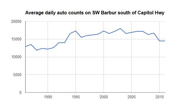
How much traffic will increase is a debate that affects us in very practical ways here in Portland, where (for example) the Oregon Department of Transportation has cited future traffic increases as a reason not to improve bike lanes on Southwest Barbur even though its own data shows that auto traffic on Barbur peaked in 2003.
Andy Cotugno, the transportation planning director for regional planning agency Metro, said Wednesday that his organization won’t be affected by the federal change, in part because his team’s projections already reflect the plateau in miles driven per person.
“We’ve scaled our transportation plans down to be more realistic,” said Cotugno.
Cotugno often circulates a chart showing that in the Portland metro area, driving rates per person peaked in 1996, eight years before they did the same nationally.
But Cotugno said he worries that state DOTs and other agencies are too eager to circulate overestimates for future travel demand as a way to justify the need for more money.
Labels: fhwa, traffic forecast, vmt
Friday, January 10, 2014
Bike signals recognized by Federal Highway officials
Traffic signals that are specific to bicycles have been approved by the Federal Highway Administration and are now part of the Manual on Uniform Traffic Control Devices (MUTCD), the sign/signal bible for traffic engineers. |
| Bike signal on Custis Trail at Oak St - Google Maps |
If you've ridden the Custis Trail in Rosslyn you may have seen bike signals at the intersection of Lee Hwy and Oak St. If you click on the image on the right from Google Maps street view you can just make out the symbol of a bike in the small traffic signal above the ped hand signal.
The ped and bike signals have different timing. The bike signal stays illuminated longer because it takes less time for a cyclist to cross the intersection than it takes a pedestrian, one of the many ways in which pedestrians and bicyclists are different.
These signals can now be used without the need for special permission from FHWA. From the Streetsblog post Bike Signals Get the Green Light From Engineering Establishment:
The decision should lead to more widespread use of bike signals, which can be used to reduce conflicts between people on bikes and turning drivers, give cyclists a head start at intersections, or create a separate phase entirely for bicycle traffic. They are often used in tandem with protected bike lanes.
Prior to the Christmas Eve vote by the committee that updates the MUTCD, bike signals were considered “experimental.” Communities seeking to install them first had to fund expensive engineering studies.
But no longer. In a memo regarding the approval, Federal Highway Administration officials noted that bike signals have been shown to improve safety outcomes as well as compliance with traffic rules by cyclists. Crash rates involving cyclists have been reduced as much as 45 percent following the installation of bike signals, FHWA reports.
Hat tip to GreaterGreaterWashington.Prior to the Christmas Eve vote by the committee that updates the MUTCD, bike signals were considered “experimental.” Communities seeking to install them first had to fund expensive engineering studies.
But no longer. In a memo regarding the approval, Federal Highway Administration officials noted that bike signals have been shown to improve safety outcomes as well as compliance with traffic rules by cyclists. Crash rates involving cyclists have been reduced as much as 45 percent following the installation of bike signals, FHWA reports.
Labels: bike signals, custis trail, fhwa
Monday, December 24, 2012
Route 1 widening at Fort Belvoir
The Transportation Planning Board (TPB) was recently asked to amend the long range plan to include the widening of Route 1 from Fort Belvoir to Mt. Vernon Highway. The road will be widened to 6 lanes with a wide median that can accommodate future transit. Currently a 14-foot wide outside lane and a 10-foot shared use path are included in the design. The project is being funded and managed by the Federal Highway Administration. See the project website. |
| Route 1 widening project extent |
Several of the TPB members supported Allen's comments, including DC Councilman Mendelson and Hunter Mill District Supervisor Hudgins. The FHWA rep was asked to respond to their concerns at the January 23 TPB meeting. We'll be asking cyclists to send comments to the TPB in support of bike lanes in this project.
Here's Allen's statement. He modified the statement after the meeting, noting that the median is 32 feet wide and the 10-ftoo wide sidepath will not meander:
Statement to the National Capital Region Transportation Planning Board
by Allen Muchnick, VBF board member, December 19, 2012
Sadly, this proposed highway widening project illustrates a serious shortcoming of the TPB’s Complete Streets Policy and a failure of both of the Federal Highway Administration and the Virginia Department of Transportation to adhere to their own long-established bicycle accommodation policies.
This 3.4-mile segment of US Route 1 is the planned route of four, nationally significant, long-distance bicycling routes, three of which run from Maine to Florida; namely, AASHTOs US Bicycle Route 1, the East Coast Greenway, the Potomac Heritage National Scenic Trail, and the Adventure Cycling Association’s Atlantic Coast Bicycle Touring Route. As the Commonwealth of Virginia’s only north- south bicycling route (and even as the sole north-south bicycling route through the huge Fort Belvoir army base), this project should adequately accommodate experienced long-distance bicyclists who prefer to travel on the roadway which is considerably faster, much better designed and maintained, and arguably safer than the meandering shared-use path which will also be included in this project.
Since the mid 1990s, VDOT planning studies for the Route 1 corridor through Fairfax and Prince William Counties have consistently specified 15-foot wide curb lanes to accommodate bicycling, and 15-foot wide curb lanes for bicycling were specified in VDOT’s 2003 Route 1 Location Study and in the three draft Environmental Assessments which the FHWA endorsed in 2003. While 15-foot curb lanes are--at best-- a minimal bicycling accommodation on a roadway with 50 MPH design speed, the space could be striped as 4-foot bike lanes adjacent to 11-foot travel lanes to facilitate motorist overtaking and the comfort and safety of roadway bicyclists.
Unfortunately, in designing the current project, the FHWA has narrowed the long-planned wide curb lanes to 14 feet. While non-cyclists may consider this 12-inch narrowing to be a minor, those lost inches have a big impact on a bicyclist sharing a travel lane with 50 MPH traffic. It’s illogical to consider a 12- foot travel lane to be a minimal accommodation for motor vehicles, yet maintain that, by adding only two more feet, a bicyclist, who tracks at least 3 feet wide and deserves at least 3 feet of safe passing clearance, can safely share that space laterally with 50 MPH traffic. For decades, both FHWA and VDOT have issued policies and guidance for accommodating bicyclists on high-speed roadways. As early as 1990, VDOT’s bicycle accommodation policy called for routinely providing appropriate bicycling accommodations on US Bicycle Route segments, and in 1994 FHWA published guidance that a 15-foot wide curb lane is a bare minimum bicycling accommodation on a 50 MPH roadway.
Providing 15-foot curb lanes in this project does not require a wider roadway, although the proposed 27- foot landscaped median provides ample space for doing so. Instead, 15-foot curb lanes can be achieved simply by shaving 6 inches from the inside and middle travel lanes. We ask the TPB to require FHWA to provide at least 15-foot curb lanes for bicycling as a condition for adding this project to the TIP.
Labels: allen muchnick, fhwa, route 1, transportation planning board
Thursday, May 24, 2012
Public meeting on bike facilities on Route 1
 |
| Route 1 profile showing wide curb lanes and paved trail |
Often bicycle facilities are one of the first options to be cut from a widening project to reduce the overall width. See the proposed road profile (large pdf). All project documents on the FHWA website, including a summary of comments from the 2010 public scoping meeting that includes several references to the need for better bicycling facilities in the corridor.
A public meeting on the project is planned for Tuesday, June 5, at Hayfield Secondary School, 7630 Telegraph Road, Alexandria, VA 22315, from 6-8pm. Cyclists need to attend the meeting and speak out for safe, convenient bike facilities as part of the Route 1 project. See a Patch article about the public meeting.
See the MtVernon Patch article Mount Vernon-Area Bicyclists Could Have an Easier Commute
"Route 1 as it is now is just not adequate for bicyclists," Belle View resident Mark Murphy said. "The curb lanes are narrow and traffic is heavy and fast. There are frontage roads along some parts of Richmond Highway, but they don't run consistently."
"In my opinion, Route 1 should have striped bike lanes, but someone in VDOT did not want to promote bicycling on that high-speed roadway, and the 15 feet of space could readily be reallocated at a future time into an 11-foot travel lane plus a 4-foot bike lane," Allen Muchnick, Virginia Bicycling Federation board member.
There is a 10 foot paved trail proposed for one side of the road but it does nothing for cyclists taking short trips along the opposite side of the road. Cyclists taking longer trips generally prefer an on-road route."In my opinion, Route 1 should have striped bike lanes, but someone in VDOT did not want to promote bicycling on that high-speed roadway, and the 15 feet of space could readily be reallocated at a future time into an 11-foot travel lane plus a 4-foot bike lane," Allen Muchnick, Virginia Bicycling Federation board member.
According to Allen Muchnick of VBF, "Route 1 is of particular importance for bicycling nationally as a desired alignment for four long-distance bicycling routes: US Bicycle Route 1, the Adventure Cycling Association's Atlantic Coast Route, the Potomac Heritage National Scenic Trail, and the East Coast Greenway. Thus, providing first-class bicycling accommodations for all types of bicyclists is particularly important for this project."
See other coverage of Route 1 topics on the FABB blog.
Labels: allen muchnick, fhwa, mark murphy, route 1, vdot, woodlawn national historic site