
Post article on riding to the Wiehle station
Lucinda Shannon works downtown and lives two miles from the Wiehle-Reston East Metro station. Like many Reston residents, she started bike commuting when the station opened. Kelley, of FABB and the Reston ped bike committee, volunteered to help her find a good bike route and gave her some moral support. See Lucinda's story in the Post article, Meet the Silver Liners! We tagged along with a few new riders to see how it's going.
But how would she lug her stuff? Or ride with traffic? Or figure out what to wear?
Enter Kelley Westenhoff, chair of Reston’s Pedestrian & Bicycling Advisory Committee. Her group developed 10 route maps for residents looking to get from their neighborhoods to the new station. Committee members even offered to create individualized plans, meet people at their homes and lead them on a commute.
Labels: Silver line, wiehle station bike room, wiehle-reston east
We need better bicycle and pedestrian access to Silver Line stations now
In the Fairfax Times article Work remains to be done for bike, pedestrian projects, Stewart Schwartz summed up the situation well that exists around the new Silver Line stations |
| Photo: Fairfax Times |
“We have a lot more work to do … but we have made a lot of progress,” said Fairfax County Director of Transportation Tom Biesiadny. “We’re trying to retrofit an existing environment. That’s going to take time.”
During a study process in 2011, the county identified 39 pedestrian and bike projects needed to improve access to the four Tysons stations. About one third of those projects have been completed so far, Biesiadny said, and the Board of Supervisors has identified funding for all of them. However, it may be several years before they are all complete.
...
Bruce Wright, president of Fairfax Advocates for Better Bicycling, said he understands that it will take some time for the county to get projects done, but he believes there are some low-cost fixes that can be used in the interim to improve safety for cyclists.
For example, he said, the county could paint “sharrows” on certain key roads — a chevron with a bike symbol that indicates that bikes will be sharing the road — or install signs that state that cyclists have the right to use the full lane.
Without some additional awareness on the part of drivers, Wright said, people are hesitant to bike on roads like Westpark Drive and Gosnell Road that connect Tysons to big residential areas because they get harassed by drivers or feel unsafe.
“If Gosnell and Westpark were more bike-friendly, then I think a lot more people would bike,” Wright said.
On a positive note, Wright said there has been significant bike traffic to the Wiehle-Reston East station in Tysons, where much of the free bike parking as well as the secure 200-space indoor bike room inside the parking garage is seeing regular use.
“That is in part because Reston is such a bike-friendly community,” Wright said. “If you provide bike facilities … people will use them.”
Labels: reston, Silver line, Tysons
Walking and biking in Tysons
The opening of the Silver Line has highlighted challenges for pedestrians and bicyclists in Tysons and to a lesser extent, in Reston. Yesterday we worked with Coalition for Smarter Growth on a news release on the situation: Opening of Silver Line Prompts Public Attention to Safety Issues for Pedestrians and Bicyclists.Writing Wednesday on Greater Greater Washington, Ken Archer (Chief Technology Officer for a company in Tysons), described the difficult situation pedestrians face in trying to cross as many as nine lanes of traffic at the intersection of Tysons Boulevard and Galleria Drive, where two sides of the intersection are missing marked crosswalks.
...
“Route 7 and Route 123 remain a particularly serious problem in the Tysons plan. Despite repeated requests for these roads to be converted to true urban boulevards that allow for safe crossing along with protected bicycle lanes and good sidewalks, these roads remain virtual highways through the heart of Tysons.” said Stewart Schwartz. “A final section of Route 123 is even planned for widening to 8 lanes, as is unfortunately the case with the other segments of Routes 7 and 123 through Tysons.”
...
 |
| Routes in Red are Phase I, to be completed by 2013 |
 |
| The south side of Tysons Boulevard and Galleria Drive. Photo by Ken Archer, Greater Greater Washington |
The Fairfax County DOT has been making some progress. There are two crosswalks at the intersection of Route 123 and Tysons Boulevard, which FCDOT recently installed. But at the opposite corner, there are no crosswalks. This is where Ken Archer described pedestrians running across nine lanes of traffic without any crosswalk.
Labels: bicycle master plan, Silver line, tysons bike plan, wiehle station
Lots of bikes at Wiehle station on Monday
 |
| Bikes parked in the free bike parking outside the Wiehle bike room |
There was a bike parked in every rack at the free bike parking just outside the bike room. Each rack holds two bikes so there was still room for more bikes. I believe there are 16 racks in that space.
There were several bikes parked in the secure bike room although there was room for many more. The room can hold over 200 bikes, and the racks can be reconfigured to hold additional bikes by replacing the single inverted U racks with the vertical racks.
 |
| Bikes parked in the Wiehle bike room |
It looks like there is considerable demand for bike parking at the Wiehle station. For those who cannot find free parking, the bike room works out to costing around 25 cents/day if you use it on a daily basis ($60/year plus one-time $15 processing and fob fee). Eventually there will also be several bike racks installed on the plaza outside the station entrance.
The one comment I heard was from a woman who said that the bike room entry door was a little hard to hold open while walking a bike. An automated or auto-assist door would be much easier for cyclists entering the room.
WMATA is renting the bike lockers at the Wiehele and Tysons stations with the exceptions of those lockers on the north side of the Spring Hill station that are located on county property. This is the last message we heard from WMATA regarding rental of those lockers: "We are not ready to sign up bike locker patrons." Not sure what the problem is since the lockers are in place and seem ready to be used.
Congratulations to Fairfax County for having the foresight to work with the property developer, Comstock Partners, to build the bike room and
 |
| Racks on south side of Wiehle station |
Labels: Silver line, wiehle station, wiehle station bike room, wmata
Post Silver Line travel guide
 |
| Photo: Washington Post |
Labels: Silver line, wiehle-reston east
Bicycling to the Silver Line Stations
 |
| Commemorative SmartTrip card to be issued on July 26 |
Labels: bike locker, Silver line, wiehle station bike room
Wiehle station bike room open house recap
 |
| Supervisor Hudgins rides in with cycle convoys |
A common question people had concerned what is the best bike route to the station from their neighborhood. People are excited they will soon be able to ride to the station to take Metro to Tysons and points east.
As opposed to free parking at existing Park & Ride lots, car parking at the Wiehle station is going to cost nearly $5. A better option is to ride the short distance
 |
| Elected officials cut the ribbon on the Wiehle station garage and bike room |
Several people obtained bike room memberships at the open house. So far, over 200 people have signed up. While there is currently space for just over 200 bicycles, the county will likely sell up to 300 memberships, knowing that not everyone will want to use the facility at the same time.
We think the coming of Metro to Reston is going to lead to major changes in how people think about getting around. Many people in this area rarely or never take public transportation. It's often easier, more convenient, and cheaper, for them to drive. Many residents in Reston have never ridden a Fairfax Connector bus. I
 |
| FABB's Kerie Hitt at our info table |
Fairfax County hopes more people will consider leaving their cars at home and taking public transportation. Several bus route changes are planned, including more frequent service on some routes serving the new stations. The only permanent car parking will be at the Wiehle station, but bike parking will be available at all the stations. Bike lockers can be rented by contacting WMATA (except for the lockers on the north side of the Spring Hill station).
We were asked by a few people if we were concerned about heavy traffic around the station. We'll be riding a bike, so while we will have to be much more careful at intersections around the station, we won't have to contend with most of the expected congestion.
For detailed information about the Silver Line stations, visit WMATA's SilverLineMetro.com.
 |
| Inside the bike room |
Labels: Silver line, wiehle station bike room
Tour de Tysons Fun Family Events
 |
| Photo by Pete Beers |
- Races start at 8:00am and run to approx 5pm on Sunday June 29
- Bike Trains depart at 8:30am
- Talk - Getting there by Bike! - 10:30am
- Tysons Free Open Streets Family Fun Ride - 12:00pm
- Bike Train to Tysons - Meet up and ride to Tour de Tysons. We'll help you discover new routes to get to Tysons by bike. Starting points are:
- Barns at Wolf Trap
- Mosaic District
- Vienna Caboose
- 24 HR Fitness
- Bikes@Vienna
- REI
- Whim Pops
- Kettle Korn Guy
- Smart Markets, Inc.
- Firehook Bakery
- Balloon twister & face painter
- Halftime Food Bars
- Fairfax Advocates for Better Bicycling
- WMATA
- Crepe Love Food Truck
- Scoops 2 U Ice-Cream Food Truck
- Spokes, Etc.
Labels: Silver line, tour de tysons
Bike routes to Tysons Metro stations
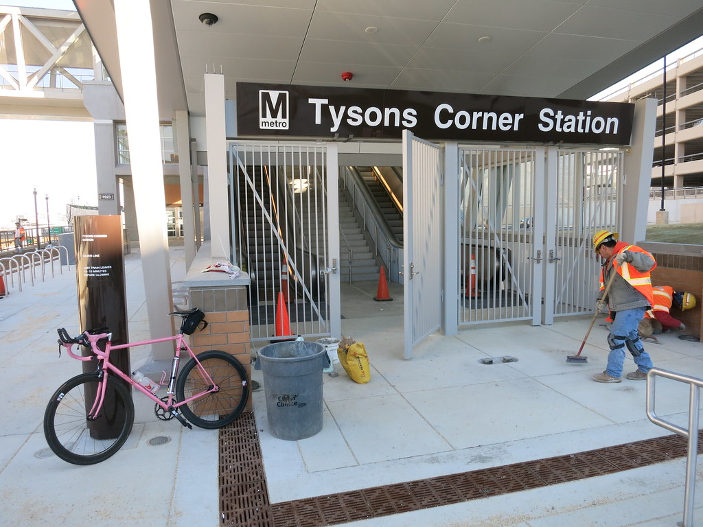 |
| Photo: Pete Beers |
When people think about traveling to Tysons they're mostly familiar with Routes 7 and 123, the Toll Road, and the Beltway. However, there are a few neighborhood streets and/or connecting trails that cyclists use to reach Tysons, completely avoiding the major roads.
FABB is working with Fairfax County, Tysons Partnership, and WMATA to promote biking to Tysons Metro stations by providing information on routes and leading rides to the stations.
Check out Pete's account of the ride, including links to maps of the routes they took:
Labels: Silver line, Tysons, tysons metro
Bicycle access to Herndon Metrorail stations - Update 15 Jan
Phase II of the Silver Line will include two rail stations in Herndon. The two stations are Herndon, site of the Herndon-Monroe Park and Ride lot, and Innovation Center near the Dulles Toll Road/Route 28 intersection. The Herndon Metrorail Stations Access Management Study (HMSAMS) is looking at bicycle and pedestrian access to these stations. You can sign up for updates on the study at the project website. From the website:The Herndon Metrorail Stations Access Management Study (HMSAMS) is a collaborative effort, led by the Fairfax County Department of Transportation (FCDOT), to develop a plan for pedestrian and bicycle facility improvements designed to improve access to and around the future Herndon and Innovation Center Metrorail Stations, located in Herndon, VA.

Labels: herndon metrorail stations access management study, hmsams, Silver line
Biking to the Silver Line
 |
| Bike parking at Spring Hill station Photo: Chris French |
There is a common misconception that there is no parking at the Tysons Metrorail stations. While it is probably not sufficient, there is bike parking at each of the four Tysons stations, and biking to the station from surrounding neighborhoods is very feasible and will get better once planned bike facilities are built.
Here's the letter:
Sally Horn of the McLean Citizens Association said “many members of her group live just far enough away that driving to a station is their best option.” For some of those residents, bicycling to the station is one of the better options. For John Lucas, who lives about a mile from the station, driving his car, parking and walking to the station entrance would probably take him longer than taking the same trip by bike. And if he biked, he would get some exercise, burn no fossil fuels, generate no pollution (short car trips generate more pollution than longer trips) and avoid adding to the already-congested Tysons streets.
Bicycling is one of the best first- and last-mile solutions. It’s not for everyone, but those who are willing to try might find it’s easier than they think.
Bruce Wright, Reston.
The writer is chairman of the Fairfax Advocates for Better Bicycling.
Labels: bicycle parking, Silver line, Tysons
Bicycling - One Answer to Gridlock
We recently appeared on the Channel 28 show Reston Impact hosted by John Lovaas. The title of the show as "Bicycling - One Answer to Gridlock?" Not sure why the question mark was there as bicycling is one of the best answers to gridlock. The focus of the show was about cycling to the new Wiehle Ave Metro station scheduled to open in Reston the end of this year/first of next year. Anne Mader of The Bike Lane was the other guest.The conversation was wide ranging but we didn't cover several topics related to biking and Metro so we have been invited back for a second taping.
Reston Impact March 2013 from Comcast Channel 28 on Vimeo.
Labels: reston impact, Silver line, the bike lane, wiehle ave
Soapstone Connector meeting Wednesday

The crossing would relieve congestion on the Reston Parkway and Wiehle Ave bridges, especially during rush hour. The new bridge would also provide easier access to the areas parallel to the Toll Road as they redevelopment. Bike-bus lanes are proposed on the bridge.
A meeting to discuss the Soapstone Connector Feasibility Study will be held on Wed., March 20 starting at 7 p.m. at South Lakes High School. See a copy of the Soapstone Connector Feasibility Study.
While we would prefer a separated bicycle facility, a shared bike-bus lane should work. They have been successfully used in several cities around the world. See a streetswiki article about bike-bus lanes. There will also be "Facility accommodation for pedestrians." Unfortunately the study does not include a bridge cross section diagram.

The bridge would eventually tie in to a planned new grid of streets that could help alleviate traffic on Sunset Hills Dr and Sunrise Valley Dr. The grid of streets and bridge would provide many more travel options through the area for motorists, cyclists, and pedestrians and foster mixed-use, transit-oriented development.
It would be good for cyclists to attend this meeting (if you don't plan to attend the FABB meeting held at the same time) and speak out for bike facilities on the bridge.
Labels: Silver line, soapstone drive
Is bike sharing feasible in Reston?

Users must first become members of Capital Bikeshare. Memberships are available for a single day, three days, 30 days, or a year. The first half hour is free, after which hourly fees apply. This pricing encourages shorter trips.
Once a bicycle is checked out it can be returned to any of the 140 stations scattered throughout the DC/Arlington area. In order to be a useful transportation alternative, a sufficient number of stations located relatively closely are needed. Users don't want to walk long distances from the stations to their destination. Ideal spacing is about 1,000 feet between stations.
With the coming of rail to Reston, many people will be traveling short distances to and from the Wiehle Ave and Reston Parkway rail stations. The "last mile" is a term used to refer to these short trips to/from transit. Bike sharing is an ideal solution.
Where would the bike stations be located? A start would be to have stations on the north and south sides of the Metro stations. The Reston Pkwy station is a long walk from the Town Center so a couple of stations could be located in parts of the Town Center. Other obvious locations include the USGS, Reston Association, Hunters Woods Village Center, the International Center, South Lakes Village Center, Newton Square, Plaza America, Stratford House, and other high density residential and commercial locations.
How would the system be funded? The Capital Bikeshare system is funded through federal, state, local and private funding. The Paris Velib bike share system is funded using advertising at the stations and on the bicycles. We currently fund other forms of transit, and bike sharing can be envisioned as a small-scale transit system that need not be self supporting. Even so, the Capital Bikeshare system is now taking in enough funds to pay for all operating expenses.
The next time you plan a short trip, think about how that trip could be taken by bike, and if a shared bike were available, would you use it? Bike sharing could be a real option for many people in Reston, but we'll need safer, more direct on- and off-road bike facilities for it to be successful. That's the topic for a future article.
Cross-posted on Reston Patch.
Labels: bike share, capital bikeshare, reston, Silver line
Bicycle: The Metro parking solution
That's the title Post editors gave to my letter to the editor about bike parking at Metro stations. It's a much better title than the online version, Metro present and future:That is correct only with respect to cars; all will have parking — bike parking. There will be space for several hundred bicycles, and more bike parking can easily be added, at a very small fraction of the cost of car parking, as was noted in the March 21 Metro article "Metro to lure bike-to-rail commuters."
Many residents around the region who live near Metro stations find that bicycling to the stations is quicker, less expensive and more convenient than driving to the station and parking. These short car trips also generate the most air pollution, since vehicles burn fuel less efficiently before properly warming up.
Hosh also asserted that Fairfax County "has outlined a bicycle path network . . ."
This is only partially correct. The county has developed a comprehensive bicycle master plan for Tysons Corner that includes recommendations for on- and off-road bicycle routes, bike parking and other end-of-trip facilities, and encouragement and education programs.
Many of these recommendations can be implemented before Metro arrives; we hope that the county hears the concerns of citizens and provides adequate funding and oversight to ensure cyclists can easily and safely access the new stations and other locations in Tysons Corner.
Bruce Wright, Reston
The writer is chairman of Fairfax Advocates for Better Bicycling.
Labels: bicycle parking, dulles metrorail, Silver line
Phase II Silver Line stations

bicycling is a low-cost, efficient way to get there.
Covered, secure, conveniently located bicycle parking is needed at these stations. Bicycle parking at the existing Orange Line stations is already beyond capacity as evidenced by bicycles being parked along fences, posts or any fixed objects. It's unsightly and an inconvenience for bicyclists not to have adequate parking. The cost is minor compared to auto parking and the benefits are greater. Bicycle access to the bicycle parking locations is important and should be considered in all station designs. The parking should be located near the station entrance, not at a remote location.
Labels: dulles metrorail, Silver line
Travel patterns to the Herndon-Monroe Park and Ride lot
By Tom WylandNational government transportation surveys have shown that the vast proportion of short trips in the US are taken by personal motor vehicle. With that in mind, we took a look at some findings from a recent Fairfax County study which included the Herndon-Monroe Park & Ride (P&R). We were curious to see if many of the car trips to this facility were short enough to be easily replaced by bike trips.
With 1,745 free parking spaces, Herndon-Monroe is the largest P&R facility in the county without co-located rail service and was constructed at a cost of $20 million. The dedicated ramps at this facility allow eastbound drivers from the Dulles Toll Road direct access into the garage. From there, drivers can take frequent express buses to metro stations, the Pentagon, Dulles Airport or DC. The transit station also acts as a local community bus hub and will be expanded for the new Herndon-Monroe metro station. A Silver line station will be located here as part of Phase II of the project.
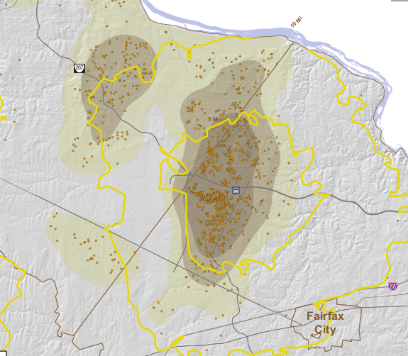
The 2008 study was performed to determine the starting locations of cars that park at the station. The results of the data reflect the two types of commuters: those who arrive from the west on the highway (from greater than 5 miles away, 38%) and those who drive on surface roads (0-5 miles, 62%). Looking at the close-up map, it is clear that many of that 62% share live within 2-3 miles of the facility, with a large cluster to the Southwest of the station (the median distance is 3.7 miles).

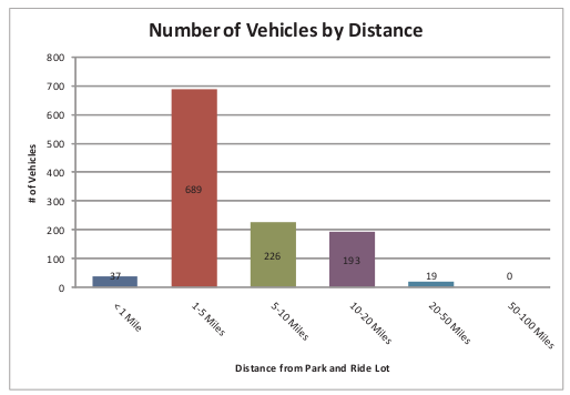
So why aren't more of the those living within five miles of the station walking or biking there? Here are some thoughts about why people drive to the station:
- Free Parking: Garage parking is free and plentiful.
- Poor North-South Connections: The bridge across the Dulles Toll Road at the station has no bicycle or pedestrian accommodations. The crossing of the Dulles Toll Rd on the Fairfax County Parkway trail is dangerous
- No Dedicated On-Road Bicycling Facilities: Sunrise Valley Dr has narrow travel lanes and the county bike map shows this as a less-preferred route for on-road bicycling.
- No Off-road Bicycling Connections: Even though the station is 0.5 miles from the heavily-biked Fairfax County Parkway and 1.5 miles from Washington & Old Dominion (W&OD) trails, there is no connection from these routes to the station. The sidepath on Sunrise Valley Dr is mostly a narrow sidewalk.
- Poor access to the West of the Station: Missing links in the existing facilities make biking and walking less attractive from this direction where most of the short-distance drivers are located.
Instead the Herndon-Monroe transit station provides abundant free car parking and easy road access for local residents with no improvements for accessing the facility by bike or foot. The redevelopment of this site as part of the Silver line expansion is a chance to reverse this trend.

Labels: dulles metrorail, herndon-monroe, Silver line
W&OD Trail closures at Dulles Toll Rd bridge

Beginning in August, there will be intermittent closures of the trail at this location during construction of the rail bridge. According to the press release below, the trail will be closed for "approximately 15 minutes or less" for placement of steel girders. Work will also be done this Fall that will entail trail closures at night. We'll try to find out more details; this is a critical commuting route used by many cyclists at night. Yes, we know technically the trail is closed after dark but it's still used by many people to get back and forth to work.
We're hopeful the August closures are less than 15 minutes. There is an easy detour shown in orange on the map. The construction site is at the blue marker. To bypass this site, you can use Sunrise Valley Dr to Wiehle Ave back to the trail (or the reverse if traveling west to east). There are sidepaths on these roads if you choose not to ride in the road. Here's the press release from the Dulles Corridor Metrorail Project:
The closings are necessary because Dulles Corridor Metrorail Project construction crews will be ramping up work on the new bridge that will carry the rail tracks, which will run in the median of the airport and toll roads, over the trail. Crews have been working on the bridge for several months and trail users have encountered some detours.
During the first week of August, crews will start site preparations for hanging and placing large steel girders on the ridge over the trail. The girder placements are currently scheduled to begin on or about Tuesday, Aug. 10. The steel girder erection work will be done during daytime hours because there are overhead power lines at this work site that would be difficult for workers to see at night.
The trail will only close temporarily when the steel girders are lifted and installed. Closures are executed to last approximately 15 minutes or less for each girder.
The affected section is located between Wiehle Avenue and Hunter Mill Road, where it crosses under the Dulles International Airport Access Highway (DIAAH) near the trail's mile marker 16. Because the future Metrorail line will run down the median of the DIAAH, this bridge is being built to support the tracks over the W&OD Trail.
Drivers in this area may also experience lane closures along the airport highway when large equipment and materials are moved to that work area prior to the steel erections.
All motorists and trail users should stay alert and use extreme caution while traveling through this area.
After the erection work is completed, crews will be building the bridge itself. Most of that work will be done at night and will require full closures of the trail. A schedule will be released later this fall and the work is expected to be completed before Thanksgiving.
Labels: Silver line, W and OD Trail


